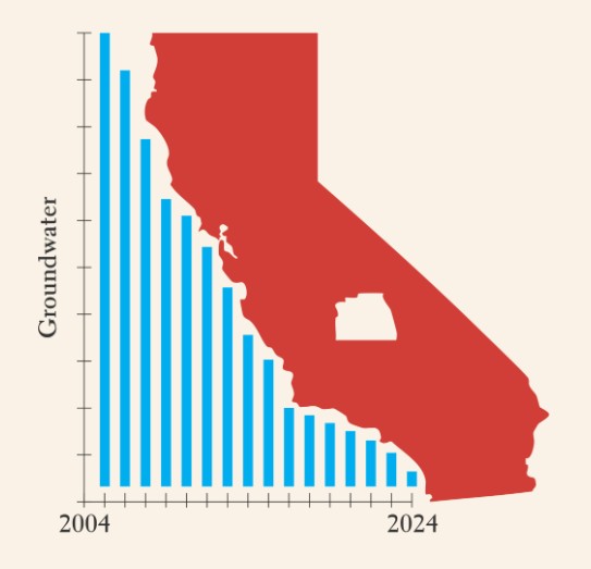
Exploring the Spatial Relationships Between Groundwater Depletion, Crops and Landcover in Tulare County, CA.
At Rediscovering the Golden State: California Geography, one of our missions is to feature the impactful work of students who apply geographic thought and analysis to pressing California issues. We’re proud to present Jason Runnels, a dedicated student from Santa Monica College.
Jason has completed a significant project titled Wells, Crops, and Crisis: Exploring the Spatial Relationships Between Groundwater Depletion, Crops and Landcover in Tulare County, CA. This timely and insightful work delves into the critical issue of groundwater depletion in Tulare County, examining its spatial relationships with agricultural practices and land cover.
We encourage you to explore Jason’s work by following the link above. Additionally, please take a moment to read his bio (see below) and learn more about his motivations for addressing this critical issue.
A twenty-five-year resident of California, Jason Runnells, the creator behind this featured project, brings a deeply personal perspective to the state’s pressing water resource challenges. With roots in a multi-generational Colorado farming family, he possesses a lifelong appreciation for the intricate relationship between land and water in semi-arid environments. This foundational interest has culminated in a focused exploration of Tulare County’s groundwater issues, a critical component of California’s larger sustainability puzzle.
This project leverages the power of Geographic Information Systems (GIS) to investigate the complex spatial interplay between shifting groundwater levels and established land use patterns. The resulting analysis provides valuable insights for the broader conversation surrounding water management and long-term environmental planning in the region.
Jason’s path to geography and GIS is as unique as his perspective. After a successful two-decade career in the music industry, a desire to more deeply understand the natural world led him back to academia. Under the mentorship of Professor Jing Liu at Santa Monica College, a passion for cartography and spatial analysis was ignited. This newfound dedication to geography has led to an internship as the GIS lead for The Canyon Alliance, where he is instrumental in developing geographic databases and tools to support local disaster preparedness efforts.
Upon graduating this spring with an associate degree in Geography, Jason will continue his studies at UCLA, pursuing a major in Geography/Environmental Studies and a minor in Geospatial Information Systems & Technologies. This project stands as a testament to his dedication and a promising glimpse into a future dedicated to applying the power of geography to real-world environmental challenges.