Figure 1: Tropical storm Kay brought rain, high winds, humidity, flash floods, and debris flows to southern California over about four days. These ominous cloud formations were observed as she made her closest approach to our coast.
This is an abbreviated final obituary to follow up on Rob O’Keefe’s earlier essay (see adjacent story) about tropical system Kay’s historic impact on California. As forecast by the National Weather Service, she skimmed along the central Baja coast as a hurricane and continued spinning toward San Diego as a weakening but distinctly organized tropical storm. As expected, Kay finally turned left and out to sea very near the southern California coast, just as the center of the storm came within 100 miles of San Diego. By Friday, September 9, bands of tropical moisture and showers were rotating north, ahead of the storm, and across southern California.
Figure 2: In late August and early September 2022, easterly flow circulated clockwise out of a giant dome of high pressure anchored over the western states. Parts of California were dominated by historic warm, moist air masses more common to the annual Sonoran and southwestern monsoon. As the marine layer was swept out to sea and the oppressive heat wave took control, especially southern California skies were often decorated with tropical clouds such as these altocumulus.
Figure 3: This 500 mb map shows Hurricane Kay charging north along the central coast of Baja. It will bump into the massive high pressure dome that was dominating western states and breaking all-time high temperature records. Easterly winds accelerated over southern California as Kay’s counterclockwise rotation met the clockwise flow out of the high. But the same high pressure ridge would steer Kay slightly west, where it would stall over the ocean just before it could hit southern California. Thursday, September 8, 2022. Source: NOAA/National Weather Service.
Figure 4: The eye of Hurricane Kay is seen just before it scrapes the Central Baja coast on its way north. Note the bands of clouds already streaming east-to-west across southern California and the monsoon thunderstorms boiling up over and east of the Sierra Nevada Mountains. Farther north, you might also notice drifting smoke from wildfires. Thursday, September 8, 2022. NOAA/National Weather Service.
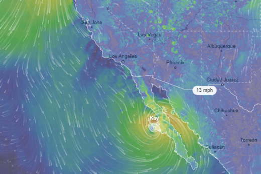
Figure 5: In this water vapor imagery, you can see Hurricane Kay carrying tons of tropical moisture as she charges north along the central Baja coast. Bands of this moisture are already circulating into southern California. September 8, 2022. NOAA/National Weather Service.
Kay’s counterclockwise rotation bumped up against and interacted with that massive, stubborn high pressure dome that was responsible for prolonged record heat across California and much of the western states. Clockwise flow out of the southern edge of that high had been pushing east-to-west offshore winds, heat, and monsoon moisture across southern California for several days. The two systems combined to produce gusty easterly hurricane-force winds in parts of San Diego County. The dramatic offshore flow spread across our deserts, over our mountains, and up the coast through Orange County and into L.A. County on Friday. As rain bands swept north of the border, dew points soared into the 70s within air columns charged with impressive precipitable water values over 2 inches! (Precipitable water (PWAT) is the total amount of water that could be drained to the surface out of any vertical column of air.)
Figure 6: Kay’s first rotating bands and easterly winds circulating up the southern California coast were impressive enough to convince any veteran storm chaser that a tropical storm was approaching. Friday, September 9.
Figure 7: Kay weakens to a tropical storm above the cooler waters off northern Baja. In this surface map, notice how it will encounter high pressure over the southwestern states. Though it will be forced to turn slightly left (west) just before hitting southern California, strong pressure gradients will drive gusty easterly winds as it approaches. Friday September 9, 2022. NOAA/National Weather Service.
Figure 8: Substantial precipitation is falling from cloud bases as the northern edge of Kay moves up the Southern California Bight. However, those easterly (offshore) winds must cascade down mountain slopes, leaving coastal locations on the rainshadow sides of local mountain barriers. This causes most of the rain to evaporate in the relatively drier air at lower elevations, leaving virga to decorate coastal skies. This also strands most coastal locations with somewhat disappointing storm totals around or below ½ inch. Friday, September 9, 2022.
Figure 9: Weakening tropical storm Kay was finally making that left turn away from land late Friday and Saturday, barely avoiding landfall in southern California. Still, she managed to circulate bands of moisture across southern California. Widespread rainfall was especially heavy late Friday until favored mountain slopes accumulated more than four inches.
Figure 10: This water vapor image illustrates how a weakening Kay still had plenty of moisture to work with as she circulated just offshore of southern California, late Friday, September 9, our time. NOAA/National Weather Service.
Two-day storm total winners received more than 4 inches of precipitation (mostly upslope mountain and foothill locations), led by Mt. Laguna at more than 5 inches. Several stations recorded wind gusts over 70 mph, with Cuyamaca Peak topping out at 109 mph. Some desert locations received as much rain as they might get in one average year. But those same easterly winds were forced downslope toward the coast, causing them to heat by compression and dry out. Much of the rain fell and then evaporated into hot, relatively dry air before it reached the ground near sea level. As Kay and her rain bands approached on Friday, Santa Monica recorded a sticky 100 degrees. Since it took some time to moisten the lower atmosphere, most coastal locations stayed near or below ½ inch rainfall totals as a combination of southern Arizona and Florida summer weather seemed to invade southern California. The storm’s thickening high- and middle-level overcast was dramatic, but it also blocked sunlight that could have otherwise heated surfaces, destabilized the air, and encouraged afternoon updrafts. As the tropical system continued weakening and wobbling around just southwest of the Southern California Bight, stratiform clouds spread across the region, making Saturday a mostly cloudy, stable, muggy day with some light precipitation. A few bands of moisture were flung all the way up into northern California and into the Basin and Range. Pressure gradients and winds continued weakening into the weekend, making way for very different impacts.
Figure 11: By Saturday, September 10, pressure gradients were easing and winds were calming as Kay spun thick stratiform clouds across southern California. Lower layers of stratus and upslope fog formed along mountain slopes in the moist air with dew points into the 70s. The atmosphere was further stabilized by the lack of surface heating without solar radiation. With Kay’s remnants spinning offshore and nothing to trigger convection, precipitation was mostly light.
Figure 12: By Sunday, September 11, a weakening and wandering Kay was drawing in drier air masses. This water vapor image proves how tremendous amounts of latent heat of condensation are required to keep tropical storms alive. Kay has lost her sources of fuel. However, in the surrounding clearing air, the sun is now able to heat land surfaces and destabilize the atmosphere. This instability is evident as afternoon thunderstorms begin popping up from the spine of northern Baja and into the moisture plume flowing across much of California. Isolated severe thunderstorms with locally heavy downpours, flash floods, and debris flows brought havoc to some mountain slopes. NOAA/National Weather Service.
Figure 13: As the remnants of Kay fizzled offshore, the storm and wind patterns flung high dew points into California. Remaining moisture conspired with afternoon surface heating to fuel thunderstorms along some isolated mountain slopes. Unlike the widespread precipitation experienced when Kay approached, these were violent hit-and-miss storms that dissipated as fast as they formed. NOAA/National Weather Service.
Sunshine returned to many areas by Sunday, but abundant residual moisture remained from the fizzling stalled storm, causing the atmosphere to destabilize. Isolated pockets boiled into severe thunderstorms, mostly over the deserts, foothills, and mountains. Flash floods ravaged some desert locations on Sunday and Monday as roads in Death Valley were washed out for the second round this summer. The mountain flood winners might have been the series of dramatic mudflows that were caught on video as they raced across parts of Oak Glen near Yucaipa and also into Forest Falls, in the San Bernardino Mountains. Another 50 people were stranded and had to be rescued when their cars were overtaken by debris flows in the Lake Hughes area west of Lancaster. Flash flooding forced temporary closure of Cal State University San Bernardino. Several daily precipitation records were set, but only in spotty locations where isolated thunderstorms erupted. The rains briefly moistened dehydrated plant communities and aided firefighters as they contained the most recent SoCal wildfires. Along the coast, water temperatures in the California Bight remained in the 70s, keeping the nights warm and contributing to that muggy feeling uncharacteristic of California.
Figure 14: As isolated afternoon thunderstorms dissipated on Sunday, they left these debris clouds to decorate the sky at sunset. Kay may have died, but her residual tropical moisture was still evident.
Figure 15: Kay’s final California chapter was written on Monday, September 12. Surface heating conspired with still enough moisture to trigger towering cumulus and a few isolated thunderstorms over local mountains. Some of the storms again became powerful enough to produce cloudbursts that caused very local flash floods and debris flows, mostly below mountain slopes ravaged by recent wildfires. Her moisture and remnant weak trough finally drifted away to the east ahead of a cooler, drier air flow pattern invading from the west.
A Final Goodbye to Kay By Tuesday, September 13, that enormous stubborn high pressure dome over the western U.S. had weakened and moved away, pushed along by a low-pressure trough forming off the northwest coast. The result was a cooler, drier flow of stable air from the west. The humidity and pop up storms bursting from Kay’s detritus were finally swept inland and east of California. Our dew points, PWATS, and temperatures dropped dramatically to more average conditions. The unprecedented days of tropical weather had ended, just as summer 2022 was coming to a close. It turns out that Kay’s path and impacts were vaguely similar to the other few and very rare tropical storms that have threatened southern California in the distant past. We are left to wonder what might have been if Kay had, instead of making that left turn off the coast, continued charging north to make landfall in southern California. And after this latest unprecedented summer, we can only speculate what might be in our weather future as the seasons change.