Part V: Sand Grain Journeys California Picture Book
Now, we invite you to join us in this final photo essay, or picture book, which takes you into the field with a variety of California sand grains, as they make their way down the mountains and on to California beaches. We were forced to be selective, since the state’s straight line distance from north to south is nearly 760 miles (1,220 km) and the entire jagged coastline includes about 1,260 miles (2,027 km) of spectacular land-meets-ocean interface diversity. We will start by eroding and transporting the rocks and sand to California’s beaches. Once on the beach, we will sweep from north to south down the coast. We will end with two videos that demonstrate how our beaches form and are changing, followed by some images of how Santa Barbara Harbor has changed since the first video was recorded more than 55 years ago.
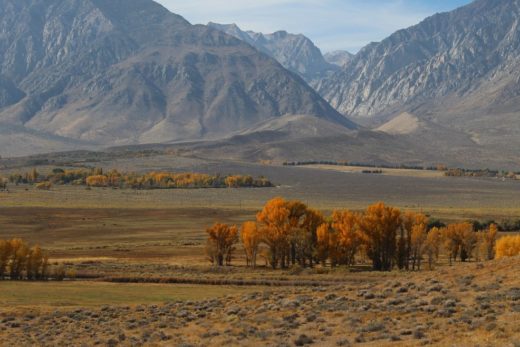
From the Mountains to the Sea? It might have taken centuries, but these granitic outcrops in the Sierra Nevada are the sources for some of the sand you are walking on when you visit many California streams or rivers or more distant beaches.
Exfoliating the Plutonic Rock. Taquitz (Lily) Rock in the San Jacinto Mountains is another example of the granitic rocks that make up the cores of many California mountain ranges. Here, exfoliation stands out as one of the weathering processes that are breaking them down. This rock has inspired epic Native American legends and continues to attract and challenge local rock climbers from around the region. Here, we might see it as more potential beach sand.
Architecture Mimicking Nature? This celebrated hotel (historically known as the Ahwahnee) looks up to the weathering granites above Yosemite Valley. Chemical and physical weathering processes that include exfoliation and frost action shear off rock falls that will gradually break into smaller fragments so that they can be transported west in the Merced River. Go to our earlier web page story about a California water drop to find out how these decomposing materials might make their journeys toward the coast.
Starting the Trip. Freshly exposed, weathered, and dislodged granitic boulders at Mist Falls high above Kings Canyon have started their epic journeys downhill and toward the west, as they break into smaller and smaller clasts.
Another Type of Weathering within another Type of Rock. We couldn’t help but share a second photo of Boyden Cave’s marvelous marbles. Such metamorphosed limestones are less common than granites in California mountain ranges. They remind us that the state is rich with many different rock formations. Many of them will not make it to our beaches, especially formations such as these stalactites, stalagmites, and columns that may readily dissolve in percolating rainwater. They are not as resistant or resilient, especially in moist environments, compared to our granitic rocks and sand grains made of quartz.
Rolling and Rounding the Rubble. As cobbles are tumbled along the stream bottom during late spring snow runoff, they are smoothed and rounded. Here, they emerge, stranded in the lower discharge typical of later in summer in the high country of the Sierra Nevada Mountains. They will continue their journeys downhill during next season’s snow melt. Their smaller pieces had better chances of making it all the way to the beach before the great dams and other human obstructions were built.
Tailings from a Mining Past. These tailings were left by aggressive and destructive dredging as gold miners swarmed into the Scott Valley in far northern California during the 1800s. They remain in the riverbed, weathering and waiting for the floods that will eventually carry them downstream and toward the coast. The State Coastal Conservancy has unveiled restoration plans to restore the Scott River drainage and its natural connections to the ocean.
Gravels and Sands Rerouted from the Riverbed. Sands and gravels, including tailings left by a gold mining bonanza, are being extracted from the Scott River Valley. According to family-owned Moore’s Gravel Inc.: “…For all your gravel needs. You call, we’ll haul.” For more than 30 years, they have been delivering to commercial and residential construction projects, especially to build driveways, roads, and parking lots throughout this region of Siskiyou County. These are base rocks, cement mixes, gravels, and sands that are being rerouted away from this riverbed that was heavily impacted by past mining. The company is working with local watershed restoration efforts designed to improve natural connections to the ocean, as it simultaneously supplies materials that are incorporated into homes, neighborhoods, and vital infrastructure.
Landslide at the Seaside. Mass Wasting processes (such as this slide at La Conchita) can deliver tremendous amounts of weathered material downhill in very short, spasmodic events. Mud and debris slides have terrorized this little seaside community for decades, including the deadly 2005 slide. In this case, the trip to the beach is just down the street and across the highway, so it shouldn’t take long for some of this material to get there.
Tumbling and Sorting. The relatively large, angular rocks suggest they are recent additions to this stream and that their source regions aren’t too far away. The smaller grains appear rounder and polished in the water, tempting us to assume they have longer histories and will be transported down to the beach a lot faster. See any gold down there?
Stranded Until the Next Season. It is hard to imagine the violent bank-to-bank torrent that may be carrying these rocks and sand to the nearby beach during next winter’s big storms. The material is not as well rounded as rocks that travel greater distances from mountain ranges farther inland over longer time periods. Here in the Santa Monica Mountains, summer’s long drought dehydrates these landscapes, in contrast to many northern California perennial rivers.
Beavers Slow Sediment Transport. These beaver dams and ponds along Mill Creek in Sierra Nevada’s Lundy Canyon represent environments where sediment is deposited. Few sand grains will get through here until winter and spring flood events flush everything down stream. This sediment was destined to be transported and deposited into inland basins.
Studying Changes in Sediment Load. The Bull Creek Watershed in northern California has been impacted by past clear cutting (that ended in the 1960s in this watershed) into the tallest trees (Coast Redwood) and some of the greatest local forest biomass on Earth. Catastrophic floods and debris flows followed the logging that exposed vulnerable, exposed slopes to the heavy seasonal rains common to redwood country. Tremendous increases in sediment yield from this and surrounding streams carried into the Eel River and flowed toward the coast. You can see why watershed restoration projects have gained much attention during the last several decades.
Does this River Look Mad to You? This is where the Mad River in northern California turns to the sea. It looks tranquil now, as it meets its protective sand spit that veers it north; but when heavy seasonal rains swell the river into flood stage, it can transport tons of sediment to the coast in a day. And this happens far more frequently along this coast just north of Arcata, compared to southern California rivers. There is one dam and reservoir upstream, but past clear cutting, grazing, road building, and destruction of riparian habitats has resulted in increased sediment yield within its relatively small and naturally more heavily forested drainage basin.
Sand, Wind, and Fog. A protective sand spit and long beach has developed that now veers the Mad River north before it finally spills into the sea north of Humboldt Bay. The finer sands on this nearby beach have been blown into dunes after they were deposited by the regions’ rivers and sorted down the beach. Native and nonnative vegetation helps to stabilize these dunes in this otherwise unstable landscape.
Stabilizing the Dunes. The Samoa Peninsula separates Arcata Bay from the ocean and protects inland developments from powerful storms and potential tsunami. Drifting sands have accumulated into these foredunes and are being stabilized by European beach grasses that have invaded natural habitats of beach pea, strawberry, and wallflowers. You can learn more about this region in a previous field trip posted on our web site: Chasing Earthquakes and Tsunami in Humboldt County and the Northwest Coast.
Another Dune Restoration Project. The finer sands that were transported to our beaches and blown into dunes now represent habitats for very specialized plants and animals. You will notice efforts to restore damaged or destroyed dune plant communities along beaches form Oregon to the Mexican Border. Humboldt’s Manila Dunes are just another example.
Quick Delivery to the Beach. Here is where the little creek at Fern Canyon spills out on to the beach, which is just behind us. During winter storms, these cobbles and other sediments are quickly transported within this relatively small drainage. Many of them look like they have been carried, rounded, and polished over great distances. However, this could be because many of them are falling out of local conglomerate rock formations, where they were deposited and lithified long ago after previously being eroded and transported greater distances in ancient streams and rivers. Regardless, they are destined to make up the materials along Gold Bluffs Beach and beyond at Prairie Creek Redwoods State Park.
Listening for the Backwash of Gold. The sands and gravels at Gold Bluffs Beach in Redwood country have been spilled out of local rivers and canyons (such as nearby Fern Canyon) and worked along by the waves. But much of it came directly off local cliffs. Early visitors in the1800s discovered that high tides and surf would erode the base of the cliffs, leaving small pieces of gold shining in the sand. Several attempts were made to mine the deposits and dredge the sands, but none of them were ever big money makers. Today, when conditions are favorable, the waves’ whooshing backwash, cascading over beach gravels, creates that calming background that resembles what you might hear on a recording of nature sound tracks.
No Beach Raking, Sifting, or Grooming Here. Surrounding forests that include coast redwoods contribute driftwood to the beaches around Prairie Creek Redwoods State Park in northern California. High and swift discharges from local streams and rivers during heavy winter storms cough logs and other biomass out of surrounding canyons. Waves work them down the beach and deposit them as high tides and storms recede. These cold, foggy, but natural beaches may seem foreign to most Southern Californians.
High Energy Erodes the Sand. Powerful waves along the Mendocino coast keep the sand moving until it lands in tiny, protected coves or is deposited in offshore bars or submarine canyons. The same waves cut sea cliffs and sea stacks, leaving only larger rocks on the beach. The darker, heavier sands (less common to California beaches) may have been weathered and eroded from remnants of a plate boundary environment when more mafic rocks were dragged toward and plastered against the continent.
Quieter Coves and Bays. After the greatest energy is exerted on exposed points and promontories, waves lose a lot of punch as they refract into more protected coves and bays. These relatively quieter environments deposit some beach sand on thin strands of otherwise high-energy northern California beaches, such as the strip in the distance. Note how sand sources that include those Franciscan Complex formations tend to be darker compared to the average California beach. This leads us to another rare name for a California beach that can be found just north of Ft. Bragg: Black Sand Beach. This Mendocino Coast is even known for its Glass Beach, where the remains of polished pieces of glass and other debris from an old trash dump have been sculpted into tiny gems sought out by beachcombers. Also note the conspicuous marine terrace we are standing on; this platform is typical of so many other wave cut platforms along the California coast that were flattened by wave action when they were near sea level, but have since been lifted up by tectonic activity. Notice how the flat underbellies of the stable marine stratus clouds seem to imitate the flat terraces that look up to them.
Fault Line Coastlines Change by the Seasons. Much of the California coast is located on or near the San Andreas and other fault zones. Just as recent mountain building has lifted fresh rock formations and ubiquitous marine terraces above the sea, waves begin eroding them, as if the ocean is trying to take back what it created and lost.
Stepping into Natural History. This informative signage on the Mendocino Coast helps to explain some of the landscape natural history common to our coastline and surveyed in this story. Here in northern California, higher terraces represent older shorelines, while the lower marine terraces were more recently lifted. Each terrace is now the foundation for unique habitats that nurture surprisingly diverse plant communities. But they are all former shorelines and wave cut platforms.
Classic High Energy Coastline. Remnant sea stacks hint where the old cliffs and shorelines extended before those high-energy waves eroded their rock formations inland. We can see how simultaneous mountain building and energetic shoreline erosion create some of the most dramatic coastlines along the Mendocino Coast. Again note the darker sands on the quieter, more protected pocket beach, suggesting they have been shed from local Franciscan Complex sources.
Carving the Shark Fin. Sand finds a resting place within the protection of Shark Fin Cove near Davenport. These weathering and eroding cliff and sea stack sedimentary formations are crumbling on to the beach, joining various sediments washed into the sea from surrounding streams and rivers. Here, pockets of sand might find some refuge from otherwise punishing wave action.
Refracting around the Points at Santa Cruz. Fine-grained, but well-lithified sedimentary rock formations stand out as resistant cliffs around Santa Cruz. They extend out to first interrupt the swells that are forced to refract around the points and then bend and spill over into the bay, creating a surfer’s paradise. Winter’s storms can generate monster waves along this coast.
Breaking on to a Quieter Beach. After the waves have refracted around nearby cliffs and points, they’ve lose a lot of energy. These smaller waves deposit sand along the more protected beach (and the Santa Cruz Boardwalk) from the power of the sea.
The Fine White Sands at Carmel. The finely ground up white sand at Carmel Beach is composed of quartz that was eroded from local granodiorites. Many of the Golden State’s sandy beaches tend to widen in summer when waves are less energetic, then thin or nearly disappear during winter’s punishing storms and heavy surf. These cycles of erosion of sand out to quieter offshore bars during winter and return of sand in summer is especially noticeable along northern and central California beaches.
Carmel Beaches Evolve. The white sandy beaches around Carmel can experience dramatic changes throughout the year. Here is another Golden State beach that is healing and returning back to nature, thanks to local restoration efforts.
Supporting Marine Ecosystems. Sandy beach habitats support very different types of organisms (such as sand crabs) compared to their turbulent rocky reef counterparts (home to kelp forests). Cold, upwelling currents mix with the California Current to nurture some of the most diverse marine life forms and productive coastal waters on Earth.
Iconic Big Sur. You can see why McCway Falls, at Julia Pfeiffer Burns State Park, is one of the most photographed landscapes along California’s central coast. The little 80-foot high “tidefalls’ dropping into the sea is about 37 miles south of Carmel. Note the patch of light-colored deposited sand, weathered from local granitic outcrops, and protected from fierce waves and currents by surrounding rock and cliff barriers. Productive kelp forests are established on the submerged rocks. Very different Franciscan rock outcrops along this Big Sur coast commonly shed darker and more colorful sands on nearby beaches.
What Goes Up Will Come Down. Tectonic activity lifts fresh rock outcrops and the Santa Lucia Mountains out of the sea to form the rugged Big Sur Coast. Waves quickly begin undercutting the cliffs. When Franciscan Complex outcrops (such as serpentine) are exposed, they often weather into unstable slopes that frequently slide back into the ocean. This creates monumental problems for road crews trying to keep Highway 1 open to the millions of tourists (roughly equal to the number of visitors to Yosemite) who visit one of the most famous coastlines in the world each year.
Delivering Material to the Beach. Since their drainage basins contain a wide range of outcrops, each canyon and its stream at Big Sur delivers many different types of sediment to the coast. This is where fluvial processes have done their jobs and coastal processes will take over.
Defining Big Sur. You can see how a series of dramatic, high-energy cliffs and little protected pocket beaches define Big Sur and draw so many millions of curious visitors each year.
Looking Down from Dune Terrace. Waves wrap around resistant Pt. Dume (to our right) and refract into this cove, depositing a small strip of sandy beach. Here, some tide pools are exposed on the wave cut platform at low tide as we stand on an older platform that has been raised as a marine terrace. Giant Coreopsis (Coreopsis gigantea) blooms on the higher rock outcrops.
The rare Giant Coreopsis (Coreopsis gigantea), only found just northwest of Malibu and on the Channel Islands, shows off above the beach sands, as it requires more stable soils than shifting sandy dunes can offer. Colorful species adapted down in the sand include Beach Primrose (Camissoniopsis cheiranthifolia), which is common on many California sandy beaches from north to south.
Cycles of Mountain Building, Erosion, and Deposition. Layers of chalky Modelo shale (ancient sea floor deposits related to Monterey shale) crumble to the sea to join sand from other sources, as it all gets transported from near Paradise Cove toward Malibu. The erosional wave cut platform forms a solid foundation for sea life to anchor in the tidal zone and then be preyed upon. These outcrops help protect the narrow sandy beach in the background.
Slowing the Migration. Finer beach sands are often blown inland, usually during winter, by strong winds. What was an annoyance can become a costly hazard when it covers roads and other human developments that may have been built on top of coastal sand dunes. Efforts to control this natural migration include this fencing. Note how wind-blown sand accumulates on the leeward sides of the obstructions, as the prevailing wind blows from right to left. It seems uncanny how sand that travelled so far in distance and time along streams and rivers, or fell off cliffs, to get to the beach, is turning back where it came from.
Strand Lines at San Onofre. The San Onofre Nuclear Power Plant was plagued by cost overruns and safety debacles until it became one of the most expensive sources of electricity in California. In the spirit of “every form of energy has its costs”, tremendous amounts of coolant water were pumped in and then released back into the ocean as thermal pollution, at the expense of local marine life. It was permanently shut down years ago, but there is continuing controversy about how to safely store the accumulated nuclear waste and protect what remains precariously close to an encroaching wave zone. You can see strand lines from high tides that made it all the way to the base of these eroding cliffs.
Ancient Beach Sands Reborn as Today’s Beach Sands. These light and brown layers of Torrey Sandstone were deposited as beach sand bars and lithified around 50 million years ago. More recently, they have been lifted above the sea so that waves, at high tide, can carve them into sea cliffs, such as at Moonlight State Beach, Encinitas. You can see how today’s cliffs seem to crumble back to the future, but what do you think might be the future of today’s beach sands?
Last Night’s Storm in the Sand. Carefully examine the sand after a significant rain shower. You will first notice how the highly porous and permeable surfaces quickly absorb water, discouraging runoff. Look closer. If it is difficult to recognize raindrop impacts, chances are good that the precipitation arrived in the form of drizzle and small raindrops falling from stratus clouds and a more stable atmosphere. If the impacts are large, the rain likely fell from vertically-developed clouds in an unstable atmosphere, where large ice crystals and hailstones grew in the upper atmospheric turbulence, fell out of the storm, and then melted before reaching sea level, finally plopping as giant raindrops into the sand.
Moving along in the Rock Cycle. These cobbles originated in igneous and metamorphic rock formations that formed more than 100 million years ago far inland of what is now Orange and San Diego Counties. They and other sediments were eroded away from those inland mountain ranges, carried by streams and rivers toward ancient coastlines, and then deposited many millions of years ago. Today’s sedimentary formations have more recently been lifted and eroded, exposing the emplaced cobbles again, so they can be carried to today’s beaches by local streams. Other cobbles are simply falling out of the local cliffs (seen in the background) and onto the beach. Their ancient streams rolled and tumbled and shaped them into smoothed spheres and they are now being abraded into smaller clasts that may become pebbles and sand. If they remain here long enough, the back-and-forth wave motions will further sculpt them into flatter shapes.
Moving Sand and Surfers Down the Beach. Here around San Clemente Pier, waves that approach the shore at angles will bend and spill over, creating excellent surfing conditions. But this wave action is also setting up longshore drift and currents that can transport tons of sand down the beach. The average visitor on the average summer day wouldn’t know that California piers have long histories of being damaged and destroyed by exceptionally fierce winter storms that transport the greatest loads of sand.
Shorelines of Submergence. In northern San Diego County, you will find shorelines of submergence that contrast with most of the coastal landscapes we have examined in this story. During the Pleistocene, when sea levels were lower, energized streams and rivers, flowing to lower base levels, sliced through the series of marine terraces that define this coastline. When climates warmed more than 11,000 years ago and much of the global ice melted, rising sea levels flooded into and submerged these same stream-cut canyons. A series of coastal lagoons formed, displaying depositional environments where sediment accumulated in the quieter waters that backed up behind higher sea levels. Here is one example at Cardiff-by-the-Sea, where San Elijo Lagoon meets the ocean. Humans have further modified this coastline with their engineering impacts and barriers that include PCH.
Sand as a Staging Area. This accessible sandy beach is valued as a staging area to get kayakers out to La Jolla’s famous sea cliffs and caves to view the rich marine life. This indented beach with gentle surf becomes a resting point for much of the sand being worked along the beaches from the more exposed, narrow, and even rocky coastline you will find both north and south of here. It’s also easier to launch your boat out into these calmer waters. The sea cliffs beyond Scripps in the distance, below Torrey Pines, and the eroding rock outcrops behind us contribute some sand to this beach.
Now, we take you to today’s Santa Barbara Harbor to illustrate how some of the same coastal processes that were discovered and studied more than 55 years ago continue to shape our coastlines. In this landmark and informative film called The Beach: River of Sand, the narration may sound old fashion, but the solid coastal geomorphology science lives on. Compare what you see in the film to our images of today’s Santa Barbara Harbor that follow: http://www.youtube.com/watch?v=FqT1g2riQ30
And before you move on to our last images in this story, you might want to go to this more current tutorial video that explores coastal processes with abundant examples from California beaches. You won’t be disappointed and you’ll never forget this lesson the next time you visit the beach: https://www.youtube.com/watch?v=vTe-SrRCxTk
Santa Barbara Harbor. We are walking along today’s breakwater that protects the boats in Santa Barbara harbor. The waves are approaching from the right and are blocked by this barrier.
Extending the Sand Spit. The migrating sand, carried by energized waves along the high-energy wall behind us, curves around the end of the breakwater and finds a calmer place to rest, accumulating on this sand spit.
The Sand Spit Grows. Waves that have refracted all the way around the end of the Santa Barbara Harbor breakwater have lost their erosive power. They deposit more sand on an extending sand spit that continues to threaten to seal the entrance to the harbor, just as it did more than 55 years ago, as shown in the video.
Looking Back along Santa Barbara Harbor’s Breakwater. Here, we turn around and look back up the coast, toward the prevailing wave direction (ahead and to the left). The protected harbor is to the right and the sand spit is just behind us and to the right.
Looking toward Santa Barbara Harbor Entrance. This view is toward the southwest. The Channel Islands can be seen in the distant far left. The breakwater is the dark structure in front of the islands and you can see the sand spit extending toward us and then curving to the right and toward the harbor. Kayakers have rowed just beyond the harbor entrance, where there is a sailboat. Without dredging, that narrow entrance would soon be filled with sand. Santa Barbara beach extends to the right and behind us. Compare this to the two videos we have referenced.
Santa Barbara Harbor Today. Looking down on Santa Barbara Harbor today, you will notice amazing similarities to the sand transport model highlighted in the film that is now more than 55 years old. The sand is being transported from the high-energy environments on the left to the calmer, depositional environments on the right. Dredging is required to keep the harbor open. Source: Library of Congress.