Autumn usually blows into California bringing dramatic pressure, wind, and geographic role reversals. Prevailing sea (onshore) breezes that dominated through summer are interrupted by land (offshore) breezes that occasionally build into violent gusty gales. This wind reversal suddenly leaves coastal regions on the leeward or downwind sides of our major mountain barriers. Moist marine air masses are squashed and then pushed out to sea. Compressional heating of air parcels that descend toward the coast produces warm, dry air masses that sweep across coastal valleys until the temporary desert comes calling all the way to the beach. What causes these sudden seasonal shifts that can suck the moisture out of every plant and animal? Follow us here, remembering that I examine these changes in more detail in my California Sky Watcher book, which will appear in a few months, published by Heyday.
Do you think these bicyclists and other passersby notice the subtle signatures left by Santa Ana winds? Breezes are nearly calm on this early November day in Koreatown, LA. But why are these tall palms leaning toward the ocean? Because past hot, dry, gusty, and desiccating Santa Ana winds have deformed them. They point away from the continent and the autumn winds that torture them, though the milder sea breezes dominate here throughout summer and many other months.
In a previous story on this website (from 2018), we illustrated where and when you might find the most impressive displays of fall colors in the Golden State. They appear on eastern Sierra Nevada and Basin and Range slopes where hot, dry continental air masses of summer suddenly yield to the frigid incoming winter. Temperatures drop below freezing and can even dive below 0° F as cold, dry continental polar air masses invade from the north and then settle east of our major mountain ranges and into Nevada. Last summer’s hot, rising air over our interior deserts created thermal low pressure that sucked sea breezes off the cooler ocean, a pattern that keeps California’s coastal strip summer weather dominated by cool and stable marine air masses. By contrast, our offshore autumn develops in that cold, dense air that settles east of our mountains, forming high pressure often referred to as the Great Basin High. Air begins flowing out of this cold high pressure and toward the relatively warmer thermal low pressure that sometimes shifts toward the coast during October and November. The cold continental air is quickly heated by compression as it sinks toward the coast, producing spectacularly warm, dry autumn days. These offshore events often produce some of the hottest days of the year along our coastal plains well into October, long after most of the tourists and crushing beach crowds have disappeared.
Pressure and wind patterns reverse during autumn as cold high pressure forms east of our major mountain barriers. This diagram from the National Weather Service was illustrated by John Blanchard in the San Francisco Chronicle. Compare it to the October and November 2023 weather maps in this story.
This 500mb upper-level map (about halfway through our atmosphere) shows a strong high pressure ridge just to our northeast in mid-October. This pattern provided ample upper-level support to produce an offshore flow, compressional heating, and very hot temperatures especially along the California coast. Source: NOAA National Centers for Environmental Prediction, Weather Prediction Center.
This surface map illustrates the strong high pressure that has formed to our northeast and a weak thermal low that has shifted to the coast. Winds flow out of those highs and toward the coast, a typical offshore pattern that pushed and squeezed compressionally-heated, dry air toward the California coast. (Note that this is the same date (October 19) as the previous upper-level map shown above. Source: NOAA National Centers for Environmental Prediction, Weather Prediction Center.
This satellite image was taken on the same date (October 19) as the previous weather maps. Note how clear skies dominate the western US under the dome of high pressure. Offhore winds keep it hot and dry all the way to the California coast. But also notice that stubborn fog is still hugging some beaches that are enshrouded in a very shallow marine layer. This occasionally occurs when offshore winds aren’t quite strong enough to scour the fog out and push it back over the ocean, or when the descending winds skim over such a very shallow inversion layer. In these cases (including this one), temperatures soar into the blazing 90s F just a few miles inland from foggy beaches where temperatures hover in the chilly 60s. Source: NOAA/National Weather Service
Strong Santa Ana winds pour out of Santa Ana Canyon and across the coastal plain, through Orange County, and toward the beach. October and November temperatures can soar well into the 80s and 90s during these offshore events. But it’s a very dry heat.
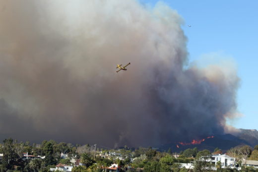
Local names often describe these offshore winds. Mono winds sweep through Sierra Nevada canyons toward the Central Valley (sometimes from the Mono Lake region). Diablo winds blow across the Bay Area toward the coast, the antitheses of summer’s Delta breezes. Santa Lucia winds descend out of the Santa Lucia Mountains toward central California beaches. And Santa Ana winds pour out of the canyons and passes of southern California and into densely populated coastal plains. This also sets up the annual race between catastrophic seasonal fires that are fanned out of control by stronger bursts of offshore winds versus the first storms of the rainy season that can douse such fires and rehydrate plant communities after the long summer drought season. Some of California’s worst conflagrations destroyed property and lives when autumn’s gusty offshore events blew through plant communities dehydrated by summer heat and drought and the late arrival of seasonal rains. We have covered these events in more detail in previous stories on this website. As of this writing, our 2023 offshore events have not been as frequent or powerful and our plant communities are not as dehydrated as in previous years when record fires terrorized Californians and scorched our landscapes. In mid-November, we wait to see if El Niño will deliver and keep it that way for a while. If you’re reading this a few months later, you already know.
Another and somewhat different offshore event resulted around October 29, when an upper-level ridge of high pressure built just off our west coast. Notice how winds blowing over and around the high pressure ridge transported cold air from Canada directly down over the Great Basin. High pressure that formed inland within the cold air at the surface was reinforced by this upper-level pattern to produce strong offshore winds across California. Source: NOAA National Centers for Environmental Prediction, Weather Prediction Center.
This satellite image (also from October 29) shows how the strong high pressure system over the west created a massive clear weather pattern that stretched from Mexico to Canada. Air masses descended out of the high over California and pushed toward the coast. Resulting offshore winds easily scoured out the marine layer and pushed it hundreds of miles out over the ocean. Source: NOAA/National Weather Service.
By the end of October, 2023, Pacific Northwest storms were already clipping northern edges of California. But they were riding over those high pressure areas that were dominating farther south and pushing offshore winds. The result was a typically warm and even dryer-than-average October from central California to the Mexican border. Note how October temperatures can soar over 100° F near the coast as offshore winds deliver the temporary desert in October. Also notice how overnight temperatures are starting to plunge in the dry air that radiates heat rapidly throughout nights that are getting longer than the days. Source: National Weather Service Oxnard Office.
As November progressed, storms streamed off the Pacific into the Pacific Northwest and skimmed over the northern edges of California. But another rather prolonged offshore event settled over central and southern California. Here, on November 12, is the last day of warm, dry weather that stretched all the way to California’s beaches. Surface high pressure that dominated for days is finally drifting east over the Rocky Mountains. Look toward the northwest and a rather complex low pressure system that will tease the state through the next several days. Source: NOAA National Centers for Environmental Prediction, Weather Prediction Center.
High pressure exits, low pressure enters. This November 12, 2023 satellite image (compare with the previous weather map) shows weather patterns in transition. As high pressure and clear skies drift to the east of California, a middle latitude wave cyclone drops into the picture (forming off the northwest coast), bringing wet instability that could sweep through the state as the first substantial storm of the season. Source: NOAA/National Weather Service.
November 11, 2023 in sunny southern California. Temperatures in the 80s in clear dry air: this is the classic weather produced by occasional offshore flow typical of autumn in California. When pressure gradients are weaker, night and morning land breezes may switch to afternoon sea breezes each day after the continent has warmed up.
It’s near sunset in mid-November, 2023 on southern California beaches. But water temperatures are still in the mid-60s and air temperatures have popped over 80 on some of these beaches during recent days. The gulls and the people seem to cherish such weather that is so common during Santa Ana conditions.
Offshore winds are gradually turning onshore during this mid-November afternoon, but temperatures remain in the 70s. Do you think these beach volleyball players are sensing the subtle changes that might lead to our first wet storm of the season … in just a few days?
We have only scratched the surface of these wild wind reversal stories that steer us away from summer and into winter. Looking for more? Stay tuned in anticipation of our new California Sky Watcher publication that will appear in a few months.
The end of another perfect November day doesn’t help us guess what kind of winter rainy season might follow. So, let’s enjoy it while we can.