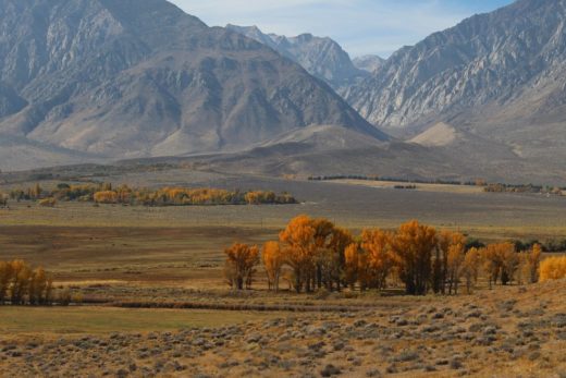
The Sierra Nevada canyons such as Yosemite and Kings and the high desert canyons sliced into the Colorado Plateau that include Zion motivate and challenge us to learn more about natural history. When I was growing up, I had a yearning desire to meet them. I first explored these jaw-dropping terrains five decades ago, just when I was deciding on my major in college. After several visits and years of research, I was lucky to study them with our students and my colleagues as we explored these glorious oddities in our field science classes.
Whether they are considered nature’s great cathedrals or breathtaking scenery without rivals, there is nothing quite like them on this planet. They helped inspire me and millions of others to learn more about the natural forces and processes that are shaping our world and how we all fit in. They and other grand landscapes in California and beyond motivated me to become the student, researcher, teacher, and naturalist that I am today. We have featured Yosemite Valley and Kings Canyon landscapes in previous stories that you will find in this project and website. In this story, we explore Zion Canyon.
How has it changed and how does this high desert canyon compare to and contrast with our Yosemite? Join me, your master ranger and natural history interpreter armed with 50 years of observations and field experiences, as I guide you to discover the science behind the scenery.


On the surface, there are some uncanny similarities between our Sierra Nevada’s Yosemite and Utah’s Zion. Each of these valleys sits at about 4,000 feet (1,200 m) above sea level, surrounded by thousands of feet of vertical rock walls soaring abruptly above their eroding rivers. Each of their names begin with the last letters of our alphabet, monikers that recall the people and cultures who once settled in these other-worldly canyons. But great differences stand out when we look a little closer.
We returned to Zion’s campgrounds during the prolonged and historic heat wave of July 2023, a month when the high temperature at their weather station (near their Human History Museum and Visitor Center) made it to 110° F (43° C) on two days. Only four days of that month had high temperatures just below 100° F (38° C), which is closer to the July average. (The highest temperature ever recorded at Zion was 115°, including July 10 and 11, 2021.) This contrasts with their typically lowest temperatures in the teens over the winter and a low of 14° F (-10° C) on January 31, 2023.
Imagine experiencing such a 124° temperature range in one location within less than six months! Welcome to cold winters and hot summers common to the thin dry continental air of the high desert. During this trip, nature forced us to alter our daily schedule so that we could hike the dry trails during early mornings and evenings and spend the hottest afternoons within the shaded narrows, immersed in the Virgin River, or at the museum or visitor center. We were rewarded with comfortable evenings to view bats darting around and then thousands of stars rotating in the dark night sky.


Weather patterns and climates in Zion are glaringly different from our Yosemite, which drains and opens toward the west, facing the Pacific Ocean. As wet winter storms stream off the Pacific, they dump copious amounts of orographic rain and snow as they glide up Sierra Nevada’s western slopes. (Check out our earlier story on the atmospheric rivers of 2023 and an even earlier story following a water drop.) Yosemite Valley averages more than 36 inches (>91 cm) of precipitation per year and the surrounding high country receives even more.
But by the time those Pacific storms skim over southern Utah’s high desert, they are usually spent, leaving only trace amounts of precipitation. Zion Canyon averages only 15.7 inches (40 cm) of precipitation and 3.8 inches (10 cm) of snow each year, compared to the massive snow drifts that accumulate in the Sierra Nevada each season. Also in contrast to our Yosemite and Kings, Zion has a distinct late summer rainy season associated with the Southwest (North American) monsoon, averaging more than an inch of rain each month from July through October. And though Yosemite may briefly be dampened by infrequent isolated summer storms, such quick hitters are not reliable precipitation producers or drought busters in what John Muir coined our Range of Light.


Torrential summer rains soaked Zion and the Desert Southwest in 2022, causing extensive flash flooding. But the North American monsoon did not perform during our visit on this sizzling July of 2023. Only 0.05 inches was recorded on the only day of precipitation that month (July 25). The fickle monsoon thunderstorm cloudbursts and flash floods will repeatedly wash out roads and trails and carry people away in the debris during one summer and then be disappointing no shows the next. Plants and animals and people who have not adapted to these high desert weather extreme realities do not survive. There is even a late summer rainy season flowering cycle on exhibit in the Southwest and across the Colorado Plateau. This is also why, when cumulus clouds begin boiling into thunderheads within the thermals that rise in summer’s midday heat, we are warned to steer clear of Zion’s narrows and slot canyons that can become violent cascading death traps within minutes. You can thank these powerful gully washers for helping to carve the deep canyons such as Zion that have made Colorado Plateau scenery world famous. In contrast, Yosemite’s Merced River and other Sierra Nevada streams and their ability to erode and deposit are dependent on runoff and snowmelt from those winter storms off the Pacific.


The Sierra Nevada and Colorado Plateau are composed of very different rock formations lifted by very different tectonic forces. The core of Yosemite and the Sierra Nevada is mostly made of massive granitic batholiths that cooled and crystalized from gargantuan underground magma chambers formed in subduction zones around 100 million years ago. More recent vertical faulting has elevated their solid granitic escarpments along steep eastern slopes until high Sierra Nevada peaks reach more than 14,000 feet (4,267 m) above sea level, while western slopes more gradually descend toward the Great Central Valley.
In contrast, the Colorado Plateau is underlain by thousands of feet of mostly sedimentary deposits that also date back more than 100 million years. Millions more years later, heat, pressure, and nature’s glues had lithified the particles into sedimentary rocks. The relatively undisturbed layers were more recently and gradually warped upward by compressional forces until the highest points of the plateau soar over 12,000 feet (>3,658 m) ASL. Gravity’s pull on water flowing from such lofty elevations has energized streams to cut deep canyons into Sierra Nevada’s granitic plutons and into the Colorado Plateau’s vulnerable layers of sedimentary rock formations.
The Grand Canyon is often used as the classic example of how a powerful river (the Colorado) can erode deep chasms as surrounding landscapes are lifted higher. Weathering and erosion will eventually widen the incised narrows over time. The relatively young Zion Canyon is also widening as the Virgin River cuts through it.

Yosemite and other Sierra Nevada canyons have been carved by floods from wet winter storms and snowmelt that runs off impressive snow packs well into the summer. But the most spectacular high country Sierra Nevada valleys and canyons were also extensively carved by alpine (mountain/valley) glaciers during previous glacial periods. As the flowing ice scraped out deep high-elevation cirques and U-shaped trenches through preexisting mountain canyons, glacial moraine rock piles were deposited downstream, leaving dramatic Ice Age landscapes. (Check out our webpage story from 2019, Norway vs. California, where we examine such glacial grandeur.)
Today’s summer storms contribute relatively little runoff into today’s Sierra Nevada streams that follow those canyons. On the Colorado Plateau, gentler cold winter rains and melting winter snows also add to frigid runoff into the canyons. And like Sierra Nevada rock formations, cycles of freezing and thawing during winter help to crack and physically weather rocks so that blocks are liberated to break off from the cliffs and eventually be carried away after they disintegrate into smaller pieces. But summer’s violent flash floods are responsible for transporting much of that loose rock and sediment downstream in Zion. And only the highest peaks and ridges of the Colorado Plateau exhibit some glacial topography; Zion Canyon and Desert Southwest landscapes were not carved by powerful Ice Age glaciers such as those that once scraped through Sierra Nevada high country.

There are also glaring differences between Yosemite and Zion in the color and texture of their rock walls. The granitic rocks of the Sierra Nevada are dominated by lighter minerals of quartz and feldspar, but are often speckled with darker crystals containing more iron and other heavier elements. This massive stew of magma chamber chemicals solidified into a solid salt-and-pepper matrix of rocks and minerals.
As the mountains were lifted, overlying rocks were weathered and stripped away, exposing them to weathering and erosion. Chemical weathering processes can be seen as dark stains and vertical streaks on the cliffs where iron and other darker elements oxidize in the water and air. Physical weathering processes include exfoliation, the pressure release that breaks massive rocks into thin skins or onion-like layers to slide and fall downslope. (Check out our website story where we follow a grain of sand.)
In contrast, the sedimentary layers of Zion are clearly and classically stacked with the older deposits on the bottom and the younger rock formations on top of them. (Still younger rocks that once capped them have been eroded and washed away long ago.) Click here for more rock layer details. The Virgin River has sliced through all of them like a sharp knife through a layer cake: nature’s road cuts. Relatively resistant lighter-colored sandstones are dominated by sandy grains with more quartz and feldspar. The layers grading from sandstones to siltstones and mudstones and shales that contain more iron and other heavier elements tend to oxidize into rusty and red colors when exposed to air and water; thinner skins of these weathered surfaces are sometimes referred to as desert varnish. And so, the highly-resistant lighter-colored speckled cliffs and canyons of the Sierra Nevada look quite different from the thousands of feet of vermilion layers of sedimentary rocks weathering in Zion. In both cases, millions of years of internal mountain building forces and external denudational processes have conspired to sculpt some of the most spectacular landscapes on Earth.
Contrasts between our Sierra Nevada and the Colorado Plateau (and particularly Yosemite and Zion) are also noticeable within their plant and animal communities. In both regions, you can find the classic vegetation zones grading from Lower Sonoran grasslands and prairies to Upper Sonoran chaparral and open woodlands, to Transition Zone woodlands and open forests, to Canadian Zone cooler and wetter forests, to still loftier subalpine Hudsonian plant communities, into the highest Arctic-Alpine Zone islands. But wetter Sierra Nevada slopes nurture lusher forests with species such as Giant Sequoias (Sequoiadendron gianteum, the largest trees on Earth) that you won’t find on the drier Colorado Plateau.
So, as you climb up from lower elevations in Zion toward higher elevations on the Colorado Plateau, you will notice high desert xeric species. They include Rabbitbrush (Ericameria nauseosa), Big Basin Sagebrush (Artemesia tridentata), and several different species of buckwheat. A little higher up, you will find what some call pygmy woodlands. Pinyon pines (Pinus monophylla and Pinus edulis) grow with live oaks and other oak species that shed their leaves, growing from shrubs into small trees. They mix with Utah Juniper (Juniperus osteosperma) at lower elevations around 4,000-5,500 feet in the Upper Sonoran and Red Cedar (Juniperus scopulorum) at higher elevations above 5,000 feet in Transition and Canadian Zones. Ponderosa Pines (Pinus ponderosa) appear and grow denser at higher elevations as we make our way into wetter mixed conifer and aspen forests with Douglas Fir (Pseudotauga menziesii), White Fir (Abies concolor), White Pine (Pinus strobiformus), and Quaking Aspen (Populus tremuloides). You also will find a host of colorful wildflowers decorating the understories at these higher elevations. Several species bloom throughout the summer, nurtured by those monsoon thundershowers that more commonly soak the cooler high plateau.
As with riparian communities in the Sierra Nevada, biomass and species diversity dramatically increase along and adjacent to stream and river courses. Where soils remain damp and the relative humidity increases around water courses in Zion, look for denser stands of Fremont Cottonwood (Populus fremontii), Red Birch (Betula occidentalis), various willow species, cattails, and rushes. As you enter the narrows where natural springs and seeps erupt from the sandstone cliff faces, look for fern and other water-loving species that combine in rock cracks to form delicate hanging gardens. Water might also be king in California, but life-giving moisture can transform Colorado Plateau’s dehydrated high desert into productive ecosystems that support numerous species of plants and animals.


Zion’s birds share the advantage of flying to water and food sources. We spotted some raptors, roadrunners, ravens, turkey vultures, and a condor flying overhead. But the real flying shows in Zion start just after sunset, when a seemingly chaotic air show of bats dart around, using their sophisticated radar to hunt and keep insect populations under control. You will also find the greatest number of species and densest populations of animals around Zion’s water courses. We saw wild turkeys, mule deer, and fox in the canyon. Raccoons, skunks, bobcats, porcupines, and owls are also found in the riparian habitats near water, mostly at night. Coyote can be heard howling around the canyon as they hunt in the twilight and darkness. Though American Beavers (Castor Canadensis) have burrowed their lodges into the banks of the Virgin River, they are difficult to spot. They don’t build beaver dams seen along other western rivers, since the river-altering structures would be destroyed by frequent flash floods. Look for the chewing scars on cottonwood trees near the river. All of this gnawing and other beaver activity usually peak during overnight hours, when it is more difficult for predators to hunt them.
As with Yosemite, humans have impacted Zion mammals and cut predator populations in the canyon. There are only a few cougars in the entire park. Such extermination and displacement of mountain lions by early farmers and ranchers and then crowds of visitors caused an unnatural explosion of deer populations. These ubiquitous browsers then feed on cottonwood and other seedlings to reduce the normal rate of plant regrowth. The results include decreasing biodiversity and increasing impacts on populations of many different riparian species. Add efforts to control reoccurring flood damage and you can see how natural channel flow has been destabilized along the Virgin River. This is another classic example of how human impacts can become ripple effects that can change natural systems and cycles and then entire landscapes, even in our national parks.

And that brings us full circle to what Yosemite and Zion might have most in common: they are perfect examples of unique landscapes of grandeur and national parks that we are loving to death. Yosemite is just about 200 miles (or four hours) from Bay Area cities, just over two hours from Central Valley population centers, and about 300 miles (6 hours) from LA. Generations of traditional Yosemite National Park lovers live in these California conurbations. Zion is only about 160 miles (2.5 hours) from a growing Las Vegas. Each of these nearby major metropolitan areas welcomes millions of tourists each year and many of these visitors clamor to squeeze a visit to one of these iconic parks into their itineraries. Unlike those of us who adore our national parks as places to find peace and solitude and to experience and learn about nature, the average visitor spends only a few hours on the ground in those national parks. Millions of people each year exploit them as social media selfie checkoff lists.
The crowds began choking Yosemite Valley decades ago, especially on summer weekends. They brought massive traffic jams, pollution, chaos, and amusement park atmospheres in what were supposed to be exceptional natural environments to be cherished and preserved for the benefit of future generations. Yosemite experimented with reservation systems from 2020-21 and a peak hours reservations system in 2022. Park officials are currently using data gathered from these experiments to develop a Visitor Access Management Plan and you are invited to provide your input. Avid naturalists and backcountry hikers have also been impacted, with most backcountry trails and wilderness areas requiring permits. Growing crowds traipsing to the top of Half Dome (a round-trip hike of about 15 miles with a 4,800-foot elevation gain) eventually created dangerous and sometimes deadly conditions on the steep and slippery dome. I’ve trudged to the top a few times over the years, but today’s permit system limits 300 hikers per day to make use of the chains and steps that lead up the side of the dome.

Zion National Park is challenged with similar dilemmas: how do our most beloved and popular parks offer access to the greatest number of people, without ruining the nature experience for each visitor and compromising the mission and integrity of our national parks?
Several years ago, Zion’s crowds multiplied as nearby Las Vegas grew and the Utah Office of Tourism began promotions to attract visitors from other states and from around the world. It worked too well if you enjoyed Zion for its nature experiences. The summer traffic and crowds in the canyon became so chaotic, the park was forced to close the road into the canyon to vehicles and require visitors to take the free shuttle from early spring into late fall. Another amusement park atmosphere erupted especially on summer weekends as overwhelmed tourists jammed the overwhelmed visitor center. Others were herded through the maze of winding chains that eventually led them into shuttles where they were crammed like sardines, hoping to eventually be dropped off at key stops to search for their elusive solitude. Add some stifling summer heat and you can see why rangers who wanted to interpret and share the beauty and magic of nature have been forced into crowd control that sometimes turns into safety concerns and crime control after visitors reach their boiling points; good for the businesses in adjacent Springdale, not so good for anyone seeking a quiet nature experience.
And as if to mimic Yosemite’s Half Dome, the narrow chain path up to Angel’s Landing finally got so popular, it turned into a dangerous line of frustrated climbers scrambling over one another. And so, similar to Half Dome, the National Park Service has been stringently enforcing their Angels Landing Pilot Permit Program. I’ve also meandered up the steep switchbacks to this popular peak a few times in past decades, but don’t attempt these memorable climbs without your permit these days.


Whether there are too many people searching for their peace and quiet in nature, or too many people searching for their perfect selfies to post on social media, I don’t offer any better solutions to the crowd control problems that have plagued these otherwise magical wonderlands during recent years. I do know that our world has changed since we could roll in and get first-come, first-served camping spots during the summer in our most spectacular national parks. And I wish the folks at the National Park Service the very best as they struggle to balance the often conflicting serve and preserve missions.
For your part, it is best to visit these magnificent gems off season during weekdays when possible. Or, you can find your solitude at nearby less popular and more remote natural sanctuaries; there are still plenty to choose from that can be just as rewarding and many have been highlighted in stories on this website. In California, some of these retreats are closer to home and more easily accessible than you might think.


If you have a little more time, come along on the following bonus trip. Let’s move up to the plateau more than 3,400 feet (>1036 m) above the canyon along what is called the West Rim Trail to see how the biogeography at higher elevations around Zion National Park is so different from the hotter and drier deserts below. We will leave the crowds behind and then leave you on the high plateau above 7,000 feet (>2,130 m) in the Zion wilderness where summers are delightfully cool (if you can avoid the occasional thunderstorms) and winters are icy cold. For those looking for an introduction to Zion from the National Park Service, check out the link at the end of our story.


Before you go, visit the official National Park Service website that will help you prepare for your adventures: https://www.nps.gov/zion/index.htm