While inland California baked and burned, why was the weather relatively cold and foggy along the immediate coast during early-to-mid summer, 2021? San Francisco and most other locations on the central and northern California coast have earned their reputations: it’s often cold in and out of the water through the middle of summer. This June and July were even a little cooler than average. Some July daytime highs near the shoreline never made it to 60 degrees F (15.5 C). Slightly cooler than average near shore ocean temperatures were at least partially to blame for this chill; water and air temperatures were running a few degrees cooler than average all the way down to the Mexican Border, where daytime highs often only peaked in the 60s even along the Southern California Bight.
(Note: Where you see numbers blocked in parentheses in this text, you are encouraged to consult Page 2 of this story for some more detailed definitions and explanations.)
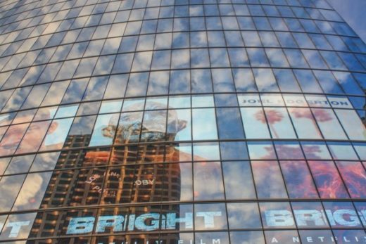
Soaring into the Fog. We can use celebrated skyline skyscrapers to measure the ceiling of low clouds that covered San Francisco on this typically chilly July morning in 2021. The Salesforce Tower is the tallest in San Francisco and, arguably, in California when we consider usable space without superficial needles attached to the architecture. Rising just more than 1,000 feet (305 m), it barely penetrates into the fog behind the infamous “leaning” Millennium Tower to the right. This not only displays the lowest altitude of condensation overnight, but the marine layer’s thickness and dominance explains why the low clouds and fog could spread several miles across the Bay and inland during coolest early morning hours. The fog would “burn off” back toward the shoreline and Golden Gate as the day warmed up.
Mild Coast versus Inland Extremes Along most coastal strips, the chill characteristically extended only a few miles inland as steep temperature gradients of up to one degree F/mile transitioned to hotter than average and even record inland temperatures. Dramatic summer temperature differences of more than 40 degrees F (22.5 C) were measured from the cool beaches to the hot inland valleys on many summer afternoons. (1) These striking contrasts between mild coastal locations, such as around San Francisco, and extreme temperatures in inland regions are evident when you examine our two adjacent sister stories about summer weather. Northeastern California’s hot summers and bitter cold winters and the southeastern deserts’ blazing summers stand out in harsh contrast to coastal climates. In our publication, we reviewed the science that helps explain these disparities. (2)
Winter in July. It’s just another cold, windy July day at Ocean Beach in San Francisco, 2021. The sea breeze cooled to its dew point over the cold California Current (ocean temperatures were in the 50s) long before rolling toward San Francisco’s coastline. You can estimate the ceiling of the low clouds by looking toward the hills of Marin County in the distance. Today’s low clouds and fog are so thick that the sun will not penetrate through, even during the afternoon, unless you move farther inland. Locals know to bundle up for their day at this beach that can be quite different from experiences they might have on southern California beaches, where water temperatures are often more than 10 degrees F (5.6 C) warmer.
Connecting Weather Systems and Regions As the summer sea breeze rushes over the cold upwelling California Current, air is chilled to its dew point. (3) The stable, dense air and cold fog drifts onshore with the prevailing surface sea breeze, racing toward summer’s expanding void known as thermal low pressure that has formed farther inland. But this air is quickly heated as it passes over warmer land, causing the shallow fog to evaporate (or “burn off”) on summer days. (4) This marine layer has remained particularly stubborn along the immediate coast this summer, just as the summer heat has been setting records farther inland and away from the cooling maritime relief. Some coastal residents have been grateful for the persistent, refreshingly cool, clean (when smoke from distant fires doesn’t swirl through) ocean air; others have grown somewhat impatient with an early summer that never happened. It’s as if coastal folks lived thousands of miles away from the intense heat of our inland valleys, the summer monsoons in our hot southeastern deserts, and the catastrophic wildfires in the dehydrated northeastern parts of our state. Still, these weather cycles and climates remain connected in sometimes stealthy and fascinating ways: for instance, the same summer afternoon sun that “burns off” the marine layer also heats the sizzling desert surface to encourage instability. But the cool summer fog keeps drifting in, slowing further drying along the immediate coastal strip during this latest drought. Evapotranspiration rates are minimized while light drizzle and fog drip may even add some moisture to coastal soils and ecosystems.
Another Cold and Gray July Day at Golden Gate Park. After reaching Ocean Beach, the fog and low clouds spread inland over the Avenues and Golden Gate Park, creating a chilly blanket that blocks the summer sun. It usually begins to evaporate and break up as it moves over the peninsula during warmer summer afternoons. But there was no clearing here on this July day when afternoon temperatures remained in the 50s.
Golden Gate Squeeze It would be difficult to find a more dramatic example of this coastal marine layer effect than San Francisco and you can thank the local geography. The shallow sea breezes and fog banks are often blocked by the coastal mountains. But there is one giant gap in the barrier we know as the Golden Gate; this iconic cleavage serves as the funnel where the marine layer can squeeze in and race through, from the ocean toward the heated inland valleys. As in most years, nearly every day this summer has offered a dramatic and picturesque demonstration of the science behind these weather scenes.
Squeezing through the Golden Gate. A cold sea breeze funnels though that scenic gap we call the Golden Gate…ocean air sent on its way to fill the void of thermal low pressure that forms within super-heated inland valleys during July. Here, as it blows from left to right, the air will begin to heat up during summer afternoons. You can often follow the fog as it thins over the bay and eventually evaporates as it moves toward East Bay locations. As the air cools at night, fog and low clouds will often thicken again and spread farther inland by morning.
Following Traditional Marine Layer Oscillations in the Summer of 2021 During this June and July, as the upper level high pressure that dominates over California summers strengthened, heavy, dense, descending air masses were heated by compression, squashing the cold marine layer and its fog closer to the ground, with thicknesses of only a few hundred feet. (5) On those days, the beaches may have been fogged in, but the marine layer didn’t extend too far inland. A thin lens of fog funneled through the Golden Gate and quickly evaporated, sometimes before reaching Alcatraz Island. Visitors may have been startled by the cold mist around the Golden Gate Bridge when it was warm and sunny just on the opposite side of town. As the upper level high pressure weakened or moved away, the marine layer thickened to more than 1,000 feet (305 m). This dominating sea breeze barreled through the Golden Gate, carrying thick layers of low clouds and fog farther inland. Its cool fingers would creep and swirl up against the Berkeley and Oakland Hills, splitting north over San Pablo Bay and south over San Francisco Bay. It would get funneled again as it passed through the Carquinez Strait and then spread out over the Delta.
Looking Down on June Gloom. We often refer to it as May gray or June gloom when the stable, relatively shallow marine layer becomes so dominant along the coast. On this morning, the thick near-surface soup has the entire coast socked in, extending into coastal valleys from the Oregon coast well down into Baja California. The fog and low stratus will retreat back over the water in many locations during the afternoon, only to reorganize for another invasion on to land after the sun sets. This image was taken as building upper level high pressure was compressing heavy, dense air masses over the Pacific Northwest and northern California inland regions, causing record-breaking heat. As such high pressure strengthens, it may eventually squash the marine layer to make it shallower and less widespread until the compressional heating may even clear the air all the way down to the surface, all the way to the beaches. Source: NOAA/National Weather Service.
Late July, 2021 Cloud Patterns. In this satellite image, typical low clouds and fog are evident along the coast from the Oregon Border down to Pt. Arguello. Note how they are not as widespread on this afternoon as they were in the morning of our previous satellite image. Also notice how surface breezes from the northwest seem to be pushing the marine layer up against southeast slopes within individual bays. Can you see how the fog and low clouds concentrate through the Golden Gate over San Francisco and creep into the Salinas Valley? Notice only one small patch of fog drifting along the northern San Diego coast. Farther inland, afternoon cumulus and some thunderstorms are popping up within summer monsoon air masses as daytime heating destabilizes moist air flowing up from the south. That cool, heavy, stable marine layer will keep these higher-altitude storms from drifting over the coast. Source: NOAA/National Weather Service.
Familiar Cycles in and Beyond the Bay But only the strongest sea breezes and thickest marine layers can carry the fog and low stratus as far as the Delta during summer months. This is because the sea air is mixing with and being modified by the hot, dry summer air masses common to our inland valleys. Each afternoon, we can observe how that summer afternoon breeze off the Bay often continues past the Delta and curves north into and up the Sacramento Valley, while another branch often veers south and down into the San Joaquin Valley. The farther it travels into these hot inland valleys, the less it resembles a sea breeze. During average summer days, when the marine layer extends a bit inland, it produces the monotonous diurnal weather cycles chanted in local weather forecasts up and down the California coast: “Late night and early morning low clouds and fog, otherwise mostly sunny during the afternoons.” Morning sunshine eventually heats the air temperature above its dew point, “burning off” the fog. After sunset, the marine air cools back to its dew point and low clouds and fog condense throughout the night and into the next morning.
Hunckering Down at the Point. A cold, stiff wind pours low stratus and fog over Fort Point, just below the Golden Gate Bridge. This fort that has guarded the Golden Gate gets a direct hit from the funneling sea breeze blowing in from behind us. Looking forward, the blue sky on the horizon to the east displays where the water drops evaporate as the shallow air mass warms above its dew point during this July afternoon.
Stop at this Sign! The folks who wrote and designed this sign deserve credit for clearly explaining the science behind the magical sky scenery and sounds at the Golden Gate.
Finding Art and Drama in Fog Science Small-scale microclimates around San Francisco Bay display remarkable contrasts that can add to some spectacular scenery. This includes the dramatic tufts and pillows of fog rolling up and over and around rugged topographic barriers, bunching here and wisping there. Perhaps the best example of this effect is when the summer marine layer carries its fog across the San Francisco Peninsula. The foggy Avenues and Golden Gate Park get direct hits. But the sea breeze piles up against Twin Peaks, forcing the fog to stream around or over these barriers of more than 920 feet (280 m). The base of landmark Sutro Tower (below 900 feet (274 m)) is often obscured as the top of the tower (about 1,811 feet (552 m) asl) pokes above the thick, cold, flowing soup. The cascading fog often gets slightly warmer and evaporates as it rolls down the opposite (or inland) sides of the hills. More often, the stable sea breeze splits around the hills, following paths of least resistance, carrying meandering, swirling fingers of fog past the north slopes and toward downtown. The encroaching fog eventually evaporates, retreating toward the coast on most summer days; it condenses again and spreads out during the cooler evenings. For most residents, these diurnal cycles and microclimates contribute to everyday scenes and life experiences in San Francisco. Such weather spectacles and sky dramas have starred in countless artworks, poems, books, and songs originating from the Bay Area since the Native Americans expressed their appreciation for them. You might be recalling one of those references right now.
July Mist at Crissy Field. Residents and savvy visitors know where to find stunning scenery and open space for recreation at Crissy field. But they have also learned to wear two or three layers to protect from the cold wind and fog whipping through the Golden Gate, especially in early summer. Temperatures stalled in the mid-50s F on this July day, but it felt like the 40s when factoring in the wind chill.
Reconnecting to our Sky Cycles Had enough of this monotonously stable winter weather in July? Wait for autumn’s offshore winds that will shove the marine layer out to sea and introduce the dry, warm air masses that are more common in September and October along the immediate coast. For now, you can leave the coast and visit our adjacent sister stories highlighting summer’s extreme weather events in southeastern and northeastern California, all parts of this miniseries. Whether we are following the coastal fog, chasing desert thunderstorms, or trying to better understand our record droughts, heat waves, and fires, summer offers a wealth of meteorological observations that can help us reconnect to and better appreciate our sky.
Summer Warming Hut? The science teaches us why visitors to Crissy Field and the Golden Gate crave hot chocolate and coffee in July. A warming hut in California, especially during July, only seems absurd until you arrive at this location.
Headed for Alcatraz? The summer sea breeze and its fog race across the Bay and over Alcatraz Island (in the background) after channeling through the Golden Gate. On this July afternoon, it will evaporate into clear skies just before it reaches the warmed slopes of the distant Berkeley and Oakland Hills.
Cold Summers in The City. Situated on the northwest end of the peninsula, the Marina and Presidio face the Golden Gate and the streams of cold breezes racing in from the ocean. Their summers remain foggier and colder than southeastern parts of the city that are more protected from what can otherwise feel like an arctic blast in July.
Looking Toward a Warm Summer. Summer afternoon temperatures are often more than 10 degrees F (5.6 C) warmer just a few miles away from San Francisco’s exposed beaches. Here, you can see how western portions of the City are still shrouded in fog, while downtown and the eastern neighborhoods (in the distance) are enjoying blue skies and summer sunshine. Afternoon temperature gradients continue farther inland until a searing heat more than 100 degrees F (38 C) is common in inland valleys.
In the Clear. Turning away from the Golden Gate and the west side of town, you will often experience bright, sunny summer afternoons. Here, we view across the east side of the peninsula and toward the Oakland and Berkeley Hills. You will find countless examples of this contrast in coastal versus inland temperatures and microclimates up and down the California coast during summer.
Blocked by the Hills. Look carefully through the lines and you can see Sutro Tower emerging through the low stratus around Twin Peaks as we look west toward the sunset. On the other side of the hills that act as barriers, the Avenues and other districts are often fogged in all day. But the shallow sea breeze with its fog and stratus is blocked by the hills, forcing it to diverge or roll and then cascade over the topographic obstructions as it follows paths of least resistance.
Measuring the Marine Layer. A closer look toward Twin Peaks and Sutro Tower from most vantage points in the Bay Area offers a great opportunity to estimate the height and strength of the marine layer during any day. Since landmark Sutro Tower is based on an 834-foot (254 m) hill and it rises 977 feet (298 m) above that, we have a rough estimate of the height of the fog from near sea level to more than 1,800 feet (549 m). A shallower marine layer won’t make it to the top of the hill, suggesting a strong high pressure system is compressing air toward the surface, resulting in inland valley heat waves. A thicker, more dominant marine layer might leave the entire tower visible, but below a taller deck of low clouds that may spread much farther inland, causing a cool spell to break the summer inland heat. Weather on most summer days falls between these extremes, making each day’s scenery dramatically different.
On the Sunny Side. Mission Dolores Park sits on the inland side of the hills, in a sunny patch that is often protected from direct hits of sea breeze. Here, you can see a lens of fog drifting from left to right around the hills and then dissipating and evaporating over downtown as it moves inland. Looking farther out across the Bay, notice the shallow layer of fog that has drifted all the way from the Golden Gate and then piled up against the East Bay hills.
Each Day’s Marine Layer Behaves Differently. On this July afternoon, a thick layer of fog drifts inland (left to right) over downtown and gradually thins out in warmer, drier air. You can even estimate the height and thickness of the fog by using the 1,000-foot-plus-high Salesforce Tower as a measuring stick.
Paths of Least Resistance. Looking toward the south side of Mission Dolores Park, the summer fog found another low point in the hill barriers so that it could follow another path of least resistance. Still, as it cascades down the hillside (from right to left) and into warmer, drier air, it gradually thins until it evaporates. Later, the low clouds and fog spread over the entire region as nighttime temperatures dropped below dewpoints.
Fog Art. This “Auspicious Clouds/Heavy Fog” street art appropriately recognizes the important role fog has played in this City by the Bay.
Using Fog and Clouds to Reconnect to Nature. This sign helps us to interpret unique street art: “The cyclical nature of clouds, water, and rain yields vitality and prosperity and evokes renewal and reinvigoration. In San Francisco, we often see clouds in the form of rolling fog enveloping hills and blanketing the Golden Gate, adding mystery, romance, and elegance to the City and its neighbors.”