When temperatures rise during early summer, residents of the desert and mountain Southwest U.S. begin anticipating the arrival of their annual monsoon season. (1) Welcome to our first in a series of three stories about California’s contrasting and sometimes puzzling weather patterns in 2021. As sun angles increase and days grow longer, searing heat begins dominating the weather in the Mojave, Sonoran, and Basin and Range deserts from east of California’s highest mountain ranges, into Arizona, Nevada, Utah, New Mexico, and across the border into Mexico. These dry, warm air masses can suck water out of soils and ecosystems well up into the high country of the southwest, leaving woodlands and forests susceptible to debilitating annual droughts and wildfires. That same intensifying heat encourages air masses near the ground to expand and become less dense, forming thermal low pressure. This surface low, and the migration of upper level pressure patterns, eventually ushers in wet, subtropical air masses to deliver invigorating water to these landscapes, especially during late summer months.
(Where you see numbers blocked in parentheses, you might consult Page 2 of this story for more detailed definitions and explanations.)
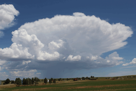
Building the First Storms. By noon on this late July day, towering cumulus were already building into cumulonimbus over the San Bernardino Mountains, penetrating through various mid- and high-level clouds. When air flows up against heated mountain slopes, it is forced to rise, expand, and cool. Ascending air masses rich with moisture (higher specific humidities and dew points) may quickly cool to saturation. This is why turbulent clouds and higher precipitation totals are more likely to be found over and near mountain ranges during the afternoons.
Following the Monsoon The summer monsoon arrives in the Southwest with towering cumulus and cumulonimbus clouds and sudden thunderstorm downpours that can deliver more rain in an hour than what may have accumulated in the previous several months. The storms become especially common during afternoon surface heating in the high country of New Mexico and Arizona, as moisture drifts up from Mexico. Many of these locations experience peak annual precipitation from July into September. (As a related update, check out this NWS story about how monsoon thunderstorms became severe and deadly in Phoenix, AZ on July 24, 2024.) Occasionally, when upper level pressure and wind patterns are favorable, this moisture and instability will drift across the California border, into southern California deserts and mountain ranges, and even up the spine of the Sierra Nevada Mountains. This usually occurs when a strong upper level high pressure system wobbles somewhere near the Four Corners Region, pushing winds clockwise around it, creating wind flow out of the southeast over us, and advecting moist air into southern parts of our state. Though only a few California locations near the Colorado River receive their peak annual precipitation during late summer (and it’s usually not much), these brief monsoonal encroachments can bring isolated summer storms more common to Flagstaff or Taos into parts of southern California and beyond.
Drifting Anvil Tops. When cumulonimbus (thunderheads) build over higher terrain, the icy anvil tops may be sheared by prevailing upper level winds, which are often stronger than winds near the surface. Here, this late July mid-day storm is building over the San Jacinto Mountains, but winds from the southeast are pushing the storm tops toward the northwest, over us and San Gorgonio (Banning) Pass.
Exceptional Storms in the Summer of 2021 During July and August of 2021, an unusually early and then wet monsoon season soaked and then flooded parts of New Mexico and Arizona with heavy rain and deadly flash flooding that even broke some records. In a few cases, the disturbances, instability, and moisture drifted into California with some spectacular results. Deserts and mountain ranges from the Colorado River to southern California’s mountain ranges, and from the Basin and Range to the Sierra Nevada had been dehydrated by months of relentless drought and record high temperatures. Suddenly, relief appeared in the form of subtropical clouds that shielded the blazing sun and then towering thunderheads carrying torrential downpours and spectacular lightning displays. Lightning strikes within drier thunderstorms with higher cloud bases increased fire dangers, while wetter storms delivered life-giving cloudbursts that quickly soaked soils and even generated some flash flooding. Though these storms were characteristically widely scattered and of short duration, this reoccurring pattern during July and into August eventually dumped surprising amounts of measurable rainfall on nearly every weather station, including places such as Death Valley.
Sudden Cloudburst Danger? As this building thunderstorm spills its columns of intense downbursts into these canyons of the San Jacintos, more than an inch (~2.5 cm) of rain can fall on one spot within an hour. When such cloudbursts fall on steep desert slopes, tremendous volumes of water are mixed with exposed, loose regolith and other detritus that has been weathering for years. The muddy mixture races through the canyons and flows out on to the relatively flat desert floor, where it will be deposited. Clueless travelers are killed by these violent flash floods and debris flows every year during the Southwest monsoon season. Successive lobes and layers of these rare and startling mud and debris flows accumulate to form alluvial fans (such as the one you see here) that spread out from canyon mouths to decorate our desert landscapes.
Monitoring and Chasing Summer Moisture I was fortunate to anticipate and then chase some of these legendary-but-misunderstood storms during one day on July 30, 2021. For several days, wind flowing from the southeast had been sporadically delivering moisture from Arizona and Mexico into the state. Record wet air masses with high dew points were flooding Arizona, even driving afternoon high temperatures down into the low 80s (~28 C)in Phoenix for three straight days, another record for July. And some of this moist air was moving across the Colorado River Valley and the Mexican Border into California.
Afternoon Thunderheads. When we view them from a distance, we can appreciate the structure of these behemoth cumulonimbus and the turbulent thunderstorms that can form over heated mountain slopes during summer. Here, you can see the icy tops of the storm boiling up over 30,000 feet (9,144 m) as it drops dense shafts of rain and hail that obscure the San Jacinto Mountains above the Coachella Valley. Also note its tilt as it is drifting from southeast to northwest (left to right) with moist upper level winds. These storms would expand during the afternoon and eventually dump more than 1.6 inches (~4 cm) of rain on Idyllwild within about two hours.
Mountains Accentuate Air Mass Ascension My search for thunderstorms started in San Gorgonio (Banning) Pass, where a thunderhead had already built over the San Bernardino Mountains by noon, delivering narrow rain columns to quench local slopes. Another impressive cumulonimbus towered higher on the south side of the pass, wavering over and near San Jacinto Peak. (2) Air flow from the southeast sheared its top over the pass. Heavy shafts of rain poured on to the northern slopes of the San Jacintos and into desert canyons, above where Hwy 111 toward Palm Springs forks off of Interstate 10. (3) I suspected that this already impressive build up could produce some surprising rainfall totals around the San Jacinto Mountains, but I wanted to monitor the development of a desert storm. (Sure enough, these mountain storms would eventually build further into the afternoon until more than 1.6 inches (~4 cm) of rain fell in Idyllwild in a violent cloudburst that lasted less than two hours.) My desert storm drama would come later in the day.
Anticipating the Desert Storm. Summer storm chasing in the California desert is a big gamble. Our monsoon season isn’t as reliable as in regions east of the Colorado River. It’s already early afternoon on July 30 and these could be typical fair weather cumulus forming within brief afternoon thermals that might soon dissipate. However, monsoon moisture has been streaming up from Mexico and Arizona and the satellite images and weather forecasts suggest that our juicy air mass with high dew points could quickly turn unstable. We’ll anchor around here and stick with these clouds of promise.
Science-savvy Gambling with Cumulus Monitoring updated radar and satellite imagery and some specifics in the forecast, I noticed the monsoon moisture still streaming in from Mexico and Arizona and so I headed east along Interstate 10 past Indio. As thunderheads continued to build over the now-distant San Jacinto and Santa Rosa Mountains, I continued east up the I 10 hill toward Chiriaco Summit. A few NWS flash flood warnings for nearby regions interrupted radio and phone reception. But as I turned off toward Joshua Tree National Park, the desert remained relatively hot and quiet with only a few small puffy cumulus clouds below a thin veil of higher clouds, all combining to decorate the sky. Following this road north, I noticed a line of small, but well-defined cumulus popping up in the afternoon thermals over the park’s peaks. And so, I decided to make my stand around here. Most casual observers might have considered these little clouds to be innocuous scene enhancers. But they were forming along a line as moist air now heated by direct afternoon sunlight was buoyed up along Joshua Tree Park’s western slopes, which rise above the Coachella Valley. After about an hour that included a short self-guided nature trail through this sizzling desert of dead and dying plants, a landscape clearly suffering from exceptional drought, my gamble paid off.
Showing Potential or Just another Innocuous Cloud? The line and cluster of cumulus built and expanded a bit, but it was already mid-afternoon. Promise came with the moist, superheated air that was streaming up the adjacent Coachella Valley from Mexico and the Colorado River Valley. As the western slopes of Joshua Tree National Park were heated by summer’s afternoon sun, stronger thermals should form over the higher desert mountains, encouraging afternoon storms. Still, many a storm chaser in similar situations has been disappointed by inviting cumulus that fizzled out when they lost their moisture and energy sources within air masses turned stable.
Tranquil Desert Turns to Violent Waterworld As suspected, the cumulus I targeted suddenly began to blossom into towering icy cauliflowers. Within another half hour, a dense rain shaft had formed and the impressive storm was producing constant rumbling thunder. Its downdrafts soon obscured desert peaks and slopes that included Monument Mountain to the northwest of the Cottonwood Springs Visitor Center, which was closed for the summer. I meandered up Pinkham Canyon dirt road toward the storm, but finally turned around, knowing what could happen should a downpour suddenly spread over me. Returning back on the main road through the park, I pushed north along Pinto Basin Road for a few miles to where it intersects Smoke Tree Wash. By then, the storm had dramatically strengthened and expanded, producing frequent lightning and violent downbursts of rain and hail from west to east across the sky and the road. A process called back-building seemed to keep the storms spreading across the park, into the prevailing winds. Roaring waterfalls from the sky were pouring over me and the surrounding exposed terrain. I stayed long enough to experience the excitement until it was raining so hard and so long that I knew it meant danger. So, I turned back around to higher ground, away from this wash with smoke trees, just before the flooding could make the road impassible. (Smoke Trees (Psorothamnus spinosus) grow in linear patterns along usually dry desert washes for a reason. Their seeds are abraded by flash floods and debris flows that encourage germination; later, the wash provides access to a little more ground water than surrounding desert terrain.)
Waiting for Relief. This was another punishing drought year with record summer heat in much of the Mojave Desert. Even the most drought-adapted desert species, such as this stalwart Creosote (Larrea tridentata), were struggling to survive. This resilient bush thrives in the Sonoran Desert (where monsoon thundershowers are more common and annual precipitation may peak in summer). But it also flourishes in the Mojave Desert, where the summer monsoon is far less reliable. It has dropped many of its leaves here, but will grow fresh leaves and numerous yellow flowers after a soaking rain that may be only a few hours away.
Turn Around, Don’t Drown By then, violent downdrafts were delivering ominous sheets of rain in buckets from storms to the west and east that then merged overhead. As winds gusted up to 40 miles per hour, funnel cloud formations could be seen rising up into the cumulonimbus after nearly touching the desert floor. It turned almost as dark as night on this July 30 afternoon. It would have been nice to try to document the few hours of potentially deadly flooding that damaged and closed roads within the park. But, I was wise to follow the “turn around, don’t drown” rule that echoes across the Southwest during this time of year. So, I headed back uphill toward the Cottonwood Visitor Center, out from under the frequent lightning strikes and curtains of roaring torrential rain that had created this temporary chaotic waterworld in the California desert. Violent storms continued migrating across the park, sending destabilizing outflows ahead and feeding off the remaining heat rising from surfaces not yet cooled by cloudbursts. Within a couple of hours, the sun was setting, while other destabilizing heat sources were pinched out by the cooling rains. (4) A few nature photographers, attracted by the electrical displays, attempted to capture some lightning photos just before dark as the storm quickly dispersed and more quickly dissipated, mostly retreating toward the east.
Signs of Recent Weather Patterns. This Ocotillo (Fouquieria splendens) suggests the severity of recent heat and drought. When sufficient rainfall soaks desert soils, it will sprout green leaves and colorful red tubular flowers. It’s been a long, hot dry period for this dehydrated individual as we look toward the skies and those promising (or disappointing) cumulus towers.
Appreciating Summer Cycles Those who traveled across the desert that afternoon and evening were treated to what many Californians might consider an oddity. But, for most folks familiar with the desert southwest, such as vehicle passengers displaying Arizona and New Mexico and Utah license plates, it was just another example of how the summer monsoon can put on a dazzling sky show. And it is likely that the plants and animals caught under those cloudbursts, previously dehydrated and desiccated by unprecedented drought, were lucky to survive until this brief soaking that would get them through one more summer.
Arroyos without Water. This Palo Verde (Parkinsonia florida) on the left dropped its leaves a long time ago to avoid the drought. Its green bark can carry out photosynthesis until it grows new leaves after the next rainfall. Will a summer thunderstorm finally bring life-giving water to cascade down its dry wash?
Unreliable but Spectacular Most Californians are accustomed to the hours and days of more widespread, steady rains brought by winter’s migrating middle latitude wave cyclones off the North Pacific. And it is true that nearly all of the state’s precipitation is delivered from such systems that migrate farther north during the warm season, leaving us with months of summer drought. These patterns help define our Mediterranean climate. It is also true that our surprise and sporadic summer showers can’t compare to regions with direct sources of tropical air (such as around Florida) where wet thunderstorms might march across the heated land during each summer afternoon. In the Southwest, summer weather conditions and surface and upper level wind patterns must conspire to draw in moisture from more distant sources. But such infrequency doesn’t minimize the drama and excitement and the relief from summer’s dry heat that these pop-up summer thunderstorms can bring, especially along the Colorado River Valley, across inland California, and up the ridges of the Sierra Nevada Mountains.
Brutal Desert Extremes. This desert drought victim eventually died in its dry isolation. But, this afternoon, our cumulus is finally billowing higher and showing signs that relief is not far away for the fittest species that managed to hang on.
A Summer Storm is Born. The flat base of our towering cumulus (cumulus congestus) forms as heated desert thermals rise, expand, and cool to their dewpoints. When relative humidity has reached 100% at the cloud base, water vapor releases tremendous amounts of latent heat within the cloud as it condenses to lower-energy liquid water drops. Air pockets in the cloud are charge with fuel to rise even faster and billow higher, drawing in more warm, moist air. High, thin debris clouds can threaten to shield intense sunlight and slow afternoon thermals that help such storms grow, but it is too late to stop it here; the storm engine has been set in motion. This tempest will quickly build into cumulonimbus that will easily penetrate through the high clouds.
Forecasting One-tenth to Five Inches of Partly Cloudy National Weather Service forecasters are challenged by extreme variabilities and inconsistencies in local summer monsoon storm and rainfall patterns, especially when the public doesn’t understand these events. On the coastal sides of the mountains during winter and pretty much all year in the coastal basins, a 20% chance of rain means it will probably not rain, and if it does, it will be some kind of drizzle. During the southwest monsoon in inland California, there could still be an 80% chance that it won’t rain at any one location; but local folks should know that wherever isolated monsoon storms develop, they could produce memorable gullywashers and even brief serious or deadly flooding. This uncertainty doesn’t connect with most clueless visitors from coastal cities. Usually, forecasters write the estimated, generalized precipitation totals and follow it with a phrase such as “however, greater amounts may occur during storms.” As mountain weather watcher Steve Chadwick notes, it might be clearer to write, “Isolated heavy rains and flash flooding are possible throughout the forecast area”, to warn those who are less experienced. Or, they could use Steve’s more humorous interpretation of these weather events: “one-tenth to five inches of partly cloudy.”
If you are interested in more details about weather conditions during the observed storms on July 30, 2021 in Joshua Tree NP, go to Number 5 on our scientific definitions and explanations Page 2. (5)
The First Rain and Thunder. The thunderhead develops quickly with strong updrafts (to the right) and adjacent downdrafts (to the left) that deliver shafts of heavy rain to the desert surface. Lighting and thunder grow more frequent.
Darkening Skies are Dramatic Warning Signs. As the cumulonimbus grows taller, it reflects or absorbs more sunlight until the darkest cloud bottoms signal a severe storm is in progress; but this is still the beginning of our drama.
Following the Monsoon with Weather Radar. Two days before our storm-chasing photos, typical scattered afternoon thunderstorms formed over local desert and mountain locations. You can see the echoes in green (and yellow for heavy rain and hail) illustrating the spotty nature of these short-lived storms. Many locations might remain hot and dry while more than an inch of rain can fall within an hour out of a cloudburst just a few miles away. As with many days in July and into August, 2021, these storms were moving from southeast to northwest, indicating that the source of monsoon moisture was from Mexico and Arizona. Also notice how they are moving across our deserts and all the way up the spine of the Sierra Nevada Mountains. Several days of these persistent patterns delivered abundant moisture to set the stage for our day of storm chasing. Source: Weather Underground, formerly Intellicast.
Imprints Remaining from Past Storm Events. These narrow rivulets were sculpted by channeled water flowing from wet storms that may have soaked this desert months or even years earlier. This afternoon’s first giant, heavy raindrop impacts warn that today’s storm will briefly bring local rill and gully arteries back to life in dramatic fashion.
Expanding Desert Deluge. Monument Mountain and other desert terrain across Joshua Tree National Park, west of Cottonwood Springs, is now being obscured by torrential rain and hail. The storm is advancing as violent downdrafts and outflow winds push ahead of it.
Popping Up Here, There, and Everywhere. By late afternoon, the surrounding atmosphere had grown dramatically unstable as new storms gained multiple sources of moisture and energy. This storm popped up just east of the main road through Joshua Tree and began to merge with the original thunderstorm on the other side. Some of them seemed to exhibit “back building” characteristics, as storms boiled and spread upwind, into the prevailing wind direction.
Adjacent Updrafts and Downdrafts. I remained under dark clouds with strong updrafts, while looking into adjacent, violent downdrafts that were delivering sheets of rain and hail on to the desert floor. Frequent lightning and continuous rumbling thunder announced that these had become severe, dangerous storms.
Dramatic Cloud Formations Display Ominous Forces. The storms merged within minutes to create walls of downdrafts delivering powerful, drenching cloudbursts. In parts of clouds where updrafts still dominated, ragged cloud bottoms of condensation reached toward the desert floor. The water would quickly accumulate within these desert washes, so I knew I had limited time to retreat to higher ground. (Never, ever try this unless you are an experienced storm and weather observer, know what you are doing, and plan a carefully thought-out exit strategy.)
Funneling the Energy. Updrafts became so powerful that funnel-type clouds of condensation nearly touched the desert floor adjacent to violent downdrafts and inundating rain columns.
Trees of Desert Floods. Since Smoke Tree (Psorothamnus spinosus) seeds require the turbulence and abrasion of flash floods and debris flows to help them germinate, you will often find them lining desert washes. Once established, their root systems may then take advantage of underground water sources below these landscapes. This wash is about to be tested in a dramatic flash flood event.
Desert Waterworld. More than an inch of rain can fall in less than an hour below these summer afternoon cloudbursts. Powerful water currents carrying debris will soon wash down the slopes and into these channels. It’s time to practice what we preach: Turn around, don’t drown. The massive cumulonimbus above has grown tall enough to block out almost all light; the camera is adjusted here to capture light in this scene.
From Severe Drought to Drenching Flood. Before we go back to the safety of higher ground, note the desiccated nature of these plant communities that have been tortured by extreme heat and drought. The fittest have survived to live through this merciful flooding downpour that will only briefly obscure the surrounding desert terrain. This one hour of torrential rain that can total more than an inch (2.5 cm) may nurture refreshed xeric species well into the next year.
Searching for Fuel. By late afternoon, heavy rain and hail cooled surfaces under the storms and cut off their sources of energy. The turbulence and drama migrated out of the park and over distant desert terrain that remained heated, where late-day thermals were still rising.
Stability Returns at Sunset. After most desert surfaces have been cooled by precipitation and the sun begins to set, these fleeting storms often lose their sources of energy. Once updrafts are cut off, only weakening downdrafts remain, delivering gradually lighter showers and then residual drizzle to the surface. Lightning flashes become less frequent until the storms dissipate almost as fast as they formed. Rarely, when pressure patterns and winds are unusually favorable, easterly waves or powerful storm outflow boundaries can move out of Arizona, across the Colorado River, and into California, rekindling the storms overnight. (4) No such rarity will surprise us on this night.
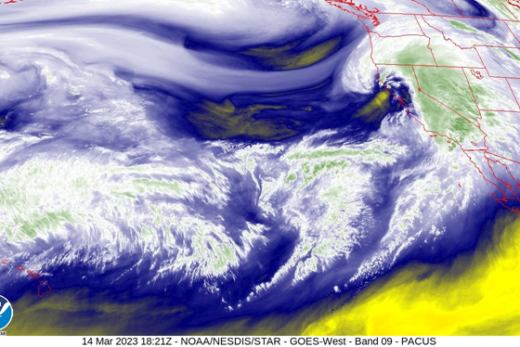
Exceptional Summer Monsoon Set Up. This satellite photo shows the stream of air flowing up from the southeast (note the shearing and drifting of taller cloud tops over the deserts). The moisture and afternoon storms typically do not cross coastal mountain barriers or encroach over cooler, more stable air masses along the coast. You can see the storms billowing along the inland sides of the mountains from Baja California into our deserts and up the spine of the Sierra Nevada Mountains. Especially southern California is caught between high pressure to the east and weak low pressure spinning counterclockwise to the west. Abundant monsoon moisture was already streaming in a full two days before our storm chasing success. Source: NOAA/National Weather Service.
Perfectly Positioned for a Summer Storm. This water vapor image illustrates how we are caught between high pressure to our east and weak low pressure to our west. The two systems conspired for days to direct winds out of Mexico and Arizona, advecting moisture into California’s inland regions. Here, there is a particularly thick glob of moisture approaching from southern Arizona. Note the circulation (in yellow) with lower dew points and specific humidity to the west. Source: NOAA/National Weather Service.
The Day After. Though some afternoon storms fired up again on the next day (including a few more back-building storms) after our storm-chasing adventures, the air mass began drying and the precipitation and drama was more isolated. More stable air masses with lower specific humidities began pushing in from the southwest, off the cooler California coastal waters. Source: NOAA/National Weather Service.
Another Day, Another Opportunity? In late June, one month before our successful storm chase, an unusually early surge of monsoon moisture broke the searing heat in the Mojave. This pattern triggered the season’s first thunderstorms to the east and all the way to the Colorado River Valley. Though it was a prelude to a banner monsoon season, most of the California desert missed out on this premature precipitation event. This is partly due to a veil of high, but thick debris clouds (cirrus, altostratus, and altocumulus leftovers) drifting off previous days’ turbulent storms and over the state from Arizona and Mexico. These clouds were thick enough to block sunlight that would have otherwise heated the surface and further destabilized the atmosphere. This combined with a lack of sufficient moisture and upper level support to discourage afternoon convection. Here, you can see this dark cumulus tower (shaded under those high clouds) boiling up as if to threaten. But it also lacked sufficient instability and moisture, collapsing in disappointment.
No Storms on this Summer Day. Summer’s first monsoon surges didn’t bring violent storms or quenching rains into these parts of the California desert. Such drama would have to wait for a few days. Still, there was just enough moisture to decorate the sky with colorful cumulus; their flat bottoms signaled condensation levels within the afternoon’s rising air columns that were expanding and cooling to their dew points. They then cast umbrellas and brief shade relieve over the Mojave Desert’s New York Mountains.
Fair Weather Cumulus. It’s already late afternoon in late June and temperatures have soared well over 100 degrees F (38 C) at Kelso Dunes. Only scattered fair weather cumulus were able to form within hot thermal columns, indicating a lack of moisture and instability that could otherwise build an isolated summer thundershower. We’ll have to wait for weather patterns to change as the summer progresses.