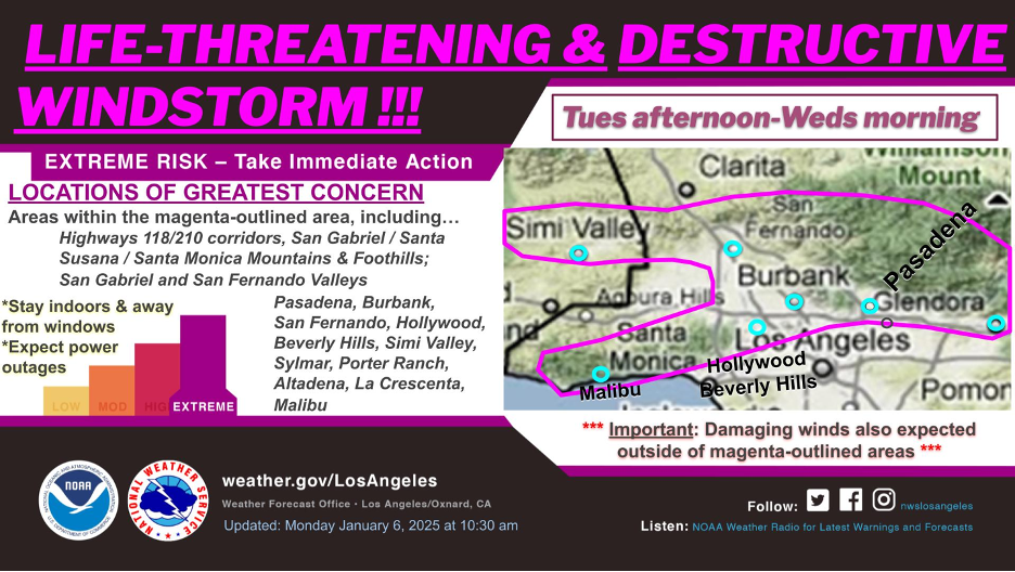
This week represents the line between the “before times” and “after times” In Los Angeles County and perhaps California. It is not hyperbole; it’s the new reality. Southern California will never be the same. And everyone finally understands that, no matter where or who you are, no person or community is immune to the ravages of nature’s awesome power when we create such imbalance. I’ve been posting stories and writing books about these realities for years. You will find them on this website and peppered throughout my California Sky Watcher book. As of this writing, we count more than 57,000 acres burned, at least 29 deaths (with more human remains still being discovered), more than 16,000 homes, businesses, and schools destroyed, and at least $250 billion in damages and recovery costs. After nearly 200,000 people were evacuated and far more lost power, entire neighborhoods and business districts were wiped out, and some of California’s most cherished natural and human landscapes have burned beyond recognition in just a few days. You can go to your TV and social media to get the dramatic, heartbreaking, and often gory details; this time, the sensationalists don’t have to exaggerate.
Here is a deeper story that explains how this happened, but more importantly, why it’s happening now. I will guide you through the play-by-play, always emphasizing the science behind the scenes, so you can see that this catastrophe is not past tense, no matter how much later you are reading about it. To set the stage, make sure you wander through our previous website story about precipitation extremes to understand how we got here.
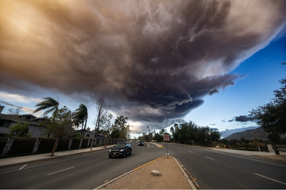
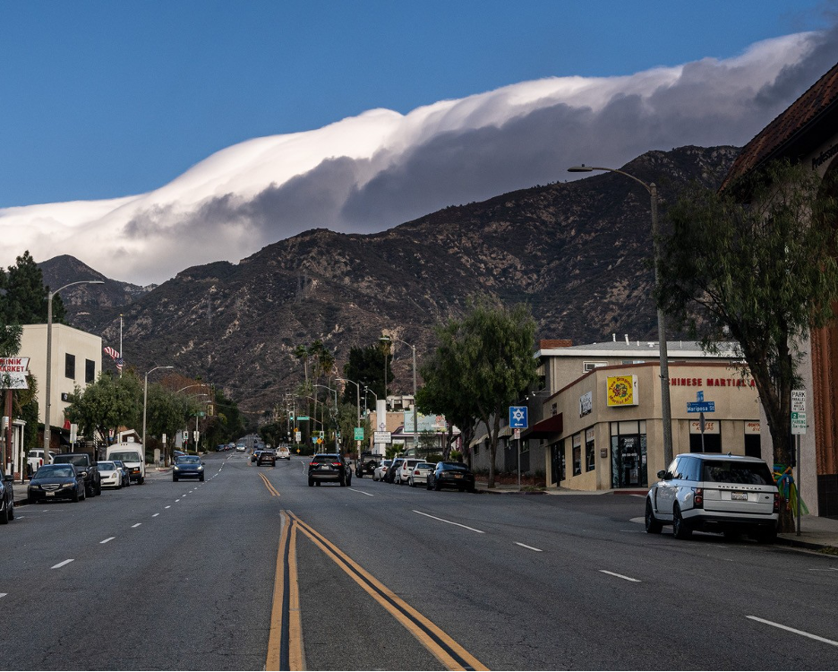
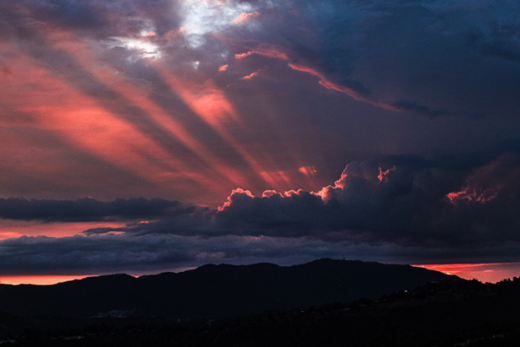
This spectacular roll cloud was photographed from New York Drive at Eaton Canyon Wash in Pasadena looking west on January 7, 2025, 7:30am. It is an example of a rotor cloud that formed on the lee side (downwind) of the mountains. High velocity stable air was forced up the opposite sides of the mountains until it reached the top. There, the relatively heavy air was liberated to tumble down this leeward side (from right to left, since it’s an offshore Santa Ana wind) past its equilibrium so that it had to rise up again as it races toward the coast, meandering up and down roller coaster style within repeating mountain waves. But a vertical circulation has formed on this leeward side. Stationary clouds condense on the top section of the rotor where air cools as it rises. Such clouds signal turbulent air and this one is an ominous precursor to the windstorm that will fan a deadly and catastrophic wildfire across Altadena and Pasadena later in the day. Photo by Matt Wright. UPDATE: Here is Matt’s message he sent with this photo: “It’s pretty violent up here right now. Top gust so far is 50 mph, but steady winds are around 30, with gusts in the low 40s. We’re all fine, but packed and ready to bug out in case of fire in the hills above us.” Sadly, their house was one of the first to burn in the deadly Eaton Fire.
Two years of heavy rains + a record nine months of drought + epic windstorms + low humidity all along the wildland-urban interface = …
It started with two years of record rainfall (competing for the most rain ever recorded in the Los Angeles area during two consecutive years), which finally broke our more than two-decades-old megadrought. Rehydrated plant communities flourished. Ecosystems added tons of biomass. Grasslands, coastal sage scrub, chaparral, oak woodlands, riparian woodlands, and every other plant community joined the party. As usual, the rain stopped last spring to make way for summer’s drought, starving our Mediterranean ecosystems of water. Through the autumn months, as water content in our plants dwindled each day, the annual race was on to see which would come first: Santa Ana winds or the first rains. Substantial early rains typically douse the fire season until next year. But, as I mentioned in the previous story on this website, the storms didn’t even show up for this year’s competition. SoCal’s widespread rainfall totals since spring remained near or below ¼ inch by mid-January, the middle of our rainy season. (As example, LA Airport had recorded only 0.04 inches and Santa Monica was at 0.09 inches for the water year well into mid-January, making this compete for the driest stretch on record for the region.)
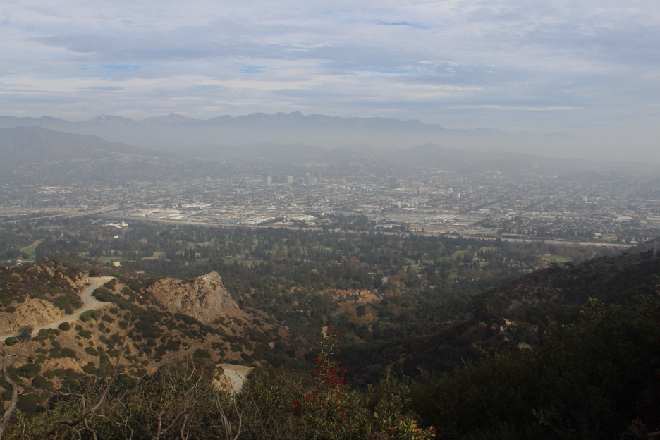
Viewing from near Mt. Hollywood in Griffith Park, look for the ripe red toyon (Christmas) berries in the middle foreground. They tell you that it’s December. But after two heavy rain years, this season started with no rain, leaving the fuels on these slopes dry and primed for ignitions. Those high and middle clouds are drifting from a storm to the north that will never get here. The same resilient high pressure that is compressing the inversion layer (note the haze and smog trapped against the mountains) is blocking potential storms. In a few weeks, these dehydrated Hollywood Hills and the distant San Gabriel Mountain slopes will erupt in flames.A mix of high clouds above LA’s Griffith Park Observatory in December and January often signal an incoming storm. Not this year. They disappointed us day after day into January.
Next, add autumn’s dry winds. By mid-November, previous gentle offshore breezes occasionally turned to classic Santa Ana winds and red flag warnings, finally sweeping shallow marine layers out to sea. Relative humidity tanked. The Mountain Fire in Camarillo scorched more than 20,000 acres, 200 structures (including homes), and destroyed millions of dollars of agricultural products in early November. By December 9, it still hadn’t rained, encouraging the Franklin Fire to terrorize Malibu all the way to PCH during another gusty Santa Ana wind event. Sadly, these were just dress rehearsals for the big shows.
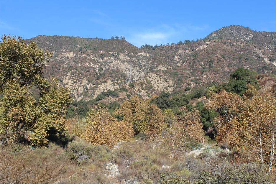
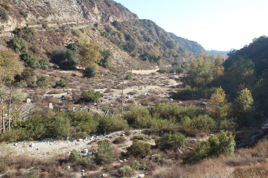
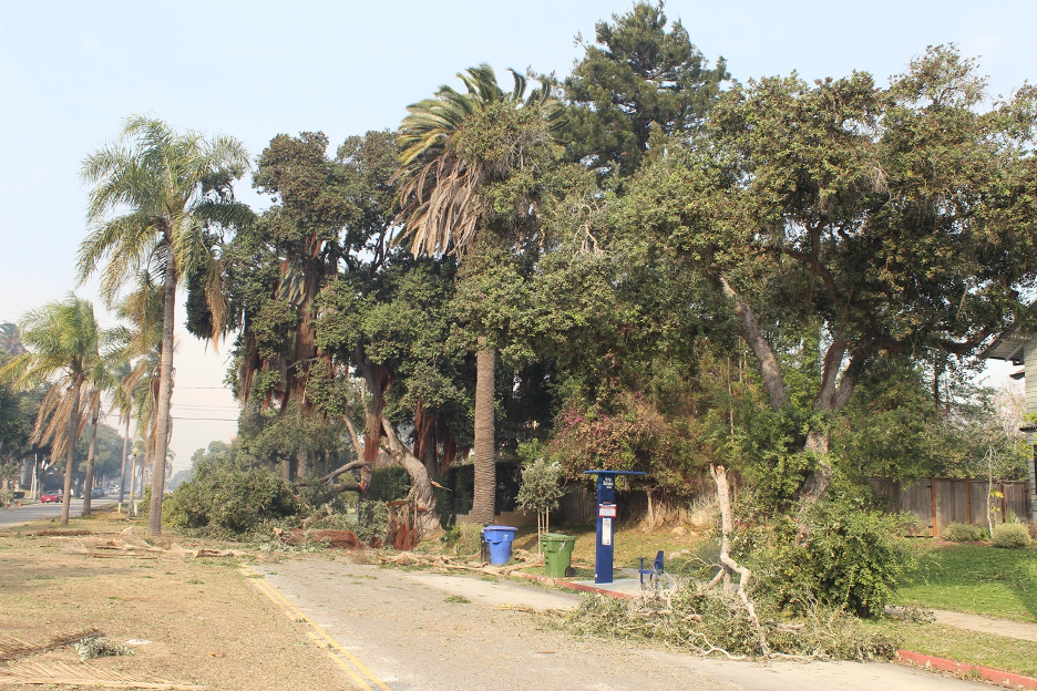
On January 1, it looked like winter in Eaton Canyon at the base of the San Gabriels. Sycamore trees had changed color, pretending to live in a colder climate. But there should be more water here this time of year. Note the dehydrated soils and vegetation more common to September or October. This is a really bad sign. Just one week later, a devastating wildfire raged off these slopes, destroying everything in its path, including Eaton Canyon’s beloved nature center.
As January progressed, offshore wind episodes became more threatening as the great drying trend expanded across the entire state. By early January, the National Weather Service was warning of dangerous, life-threatening (and possibly historic) Santa Ana winds that would barrel into Southern California on Tuesday, the 7th. Unfortunately, the forecasters nailed it. By Tuesday afternoon, the winds were howling until it seemed as if helicopters were hovering above our homes all night. I’ve written about these devil winds before on this website and in my book and I’ve experienced and researched scores of them over decades, but this was different.
Forecasters at the National Weather Service began warning us days ahead of time that this would be a game-changing Santa Ana wind.
We were caught in a wide, massive atmospheric wind tunnel midway between a low-pressure system dropping to our southeast and a strong high-pressure system trying to assert itself to our west. Upper- and lower-level support grew into an historic pressure gradient that forced cool, stable air masses toward the coast, where they would be warmed by compression. But there was another problem: the mountains were in the way. As the heavy air parcels were pushed up the opposite sides of the mountains, they eventually made it to the top, where they were free to cascade down the coastal slopes toward the ocean to become leeward waves. Widespread gusts were clocked at over 70 mph; a few made it over 90 mph. Meandering mountain waves, chaotic eddies, and violent rotary currents formed downwind of the mountains, spreading over developments, infrastructure, and millions of residents on the coastal plain. Though the powerful winds blew from the continent, wind directions would temporarily jerk one way and then the other without warning as the powerful eddies circulated by. Giant trees and power poles were toppled as power outages swept across Southern California. The big show began to resemble a terrifying scene in a science fiction movie, except you couldn’t write a script that could better prime a landscape for the ignitions that would follow.
Look carefully to see some of the visitors who will enjoy hiking Eaton Canyon for the last time before the big wildfire. There was abundant water here last year at this time, but the stream remains dry into early January, 2025. The canyon last burned more than 30 years earlier, reminding us how these plant communities have adapted to fire. Just as we mourn the unfathomable human losses of the Eaton Fire, we can’t forget how these natural landscapes play such important roles in our physical and mental health.
My chronological photo essay below illustrates how a wildfire can quickly explode into a deadly monster, consuming everything in its path until it meets the ocean. This was the case as our beloved Pacific Palisades natural and human landscapes were destroyed within a few hours this week. Given the conditions I’ve just described, it should also be no surprise that another conflagration would race out of the foothills below the San Gabriel Mountains on the same day. The death and destruction barged into Altadena and Pasadena neighborhoods that seemed far removed from the dangers of what we might consider a wildland-urban interface. (The extend of such imaginary boundaries is being reevaluated.) The greatest surprise may be how heroic firefighters were finally able to stop such an out-of-control train inferno before it did even more damage.
I’ve experienced and written about too many of these disasters over the years. The ominous red sky, the choking smoke, curious ashes fluttering down to resemble delicate snowflakes, butterfly wings, and rose petals: you may have read about them here or in my book. But I’m one of the lucky ones—so far—as these heartbreaking catastrophes become more common. Admit it or not, we all know what’s going on here. Our relationship with nature has gone seriously awry. We’re testing her and she’s winning and she always will. We’ve got to find better ways to increase our natural history and science literacy and reconnect to the real world or we’re all toast. Without such a paradigm shift, we will continue to feel the potential of the California Dream, and all that we love about our Golden State, slip away. And if you think you can simply escape to other states or countries with greener pastures, take a closer look at the chaos and dysfunction beyond our borders. Maybe if you stick around, you can play your role in righting our ship.
UCLA’s Park Williams and other researchers have teamed up to learn how much of these severe events might be connected to the bigger climate change puzzle. Click here for their most recent article.
Here’s another perspective (slightly compressed) from renowned climatologist Bill Patzert: “…decades of ‘criminal’ zoning, totally irresponsible building codes, inadequate water storage to deal with fire apocalypses and not dealing with a power delivery system that ignites fires year after year, are the major culprits.” Patzert also emphasizes that “global warming is the greatest existential threat to the environment and our civilization, but what we are living through now is human carelessness and ignoring the natural climate forces of Southern California.” But his interview with the LA Times sums up this year: “During my career, I’ve never seen punishing Santa Ana events so overwhelm the normal winter rainy season.”
Regardless, here is where my sign-offs are getting a bit repetitive: keep your seatbelts fastened.
And now follow me as we watch the peculiar behavior of the horrific wildfire that terrorized the Pacific Palisades and changed our world.
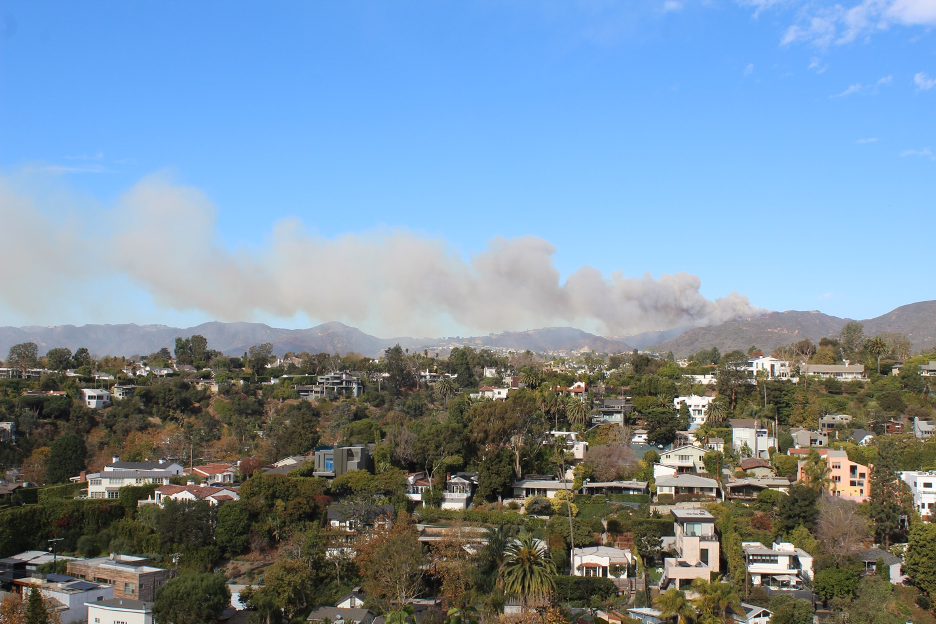
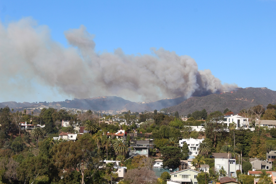
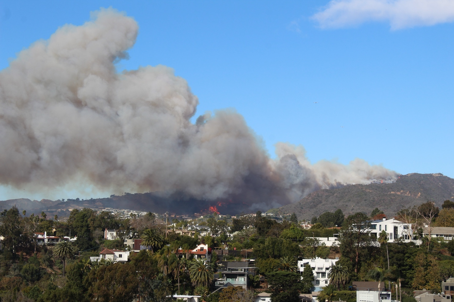
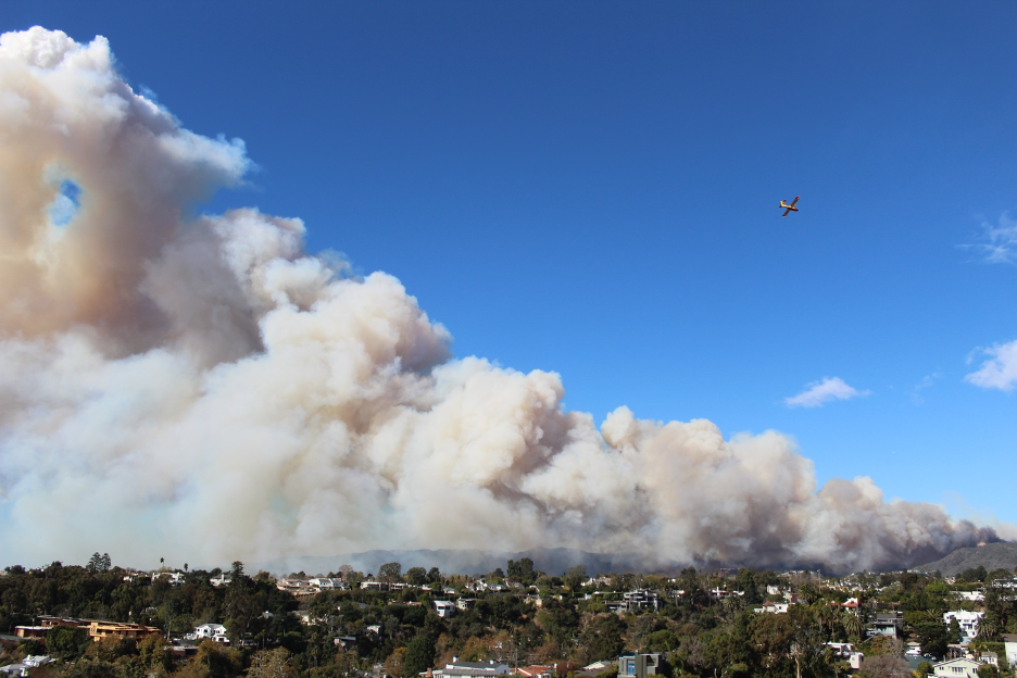
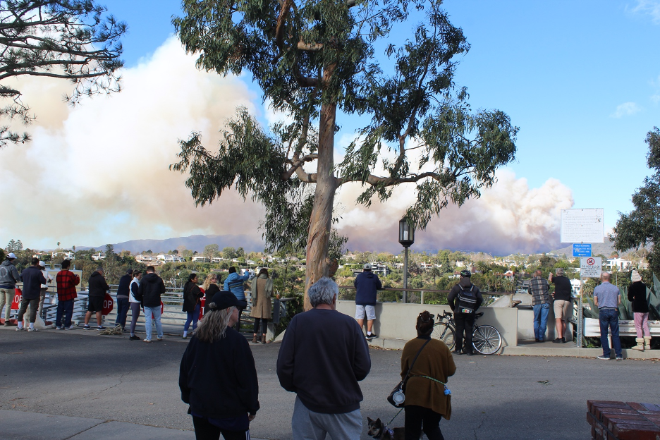
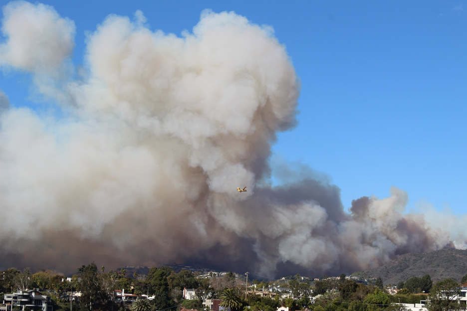
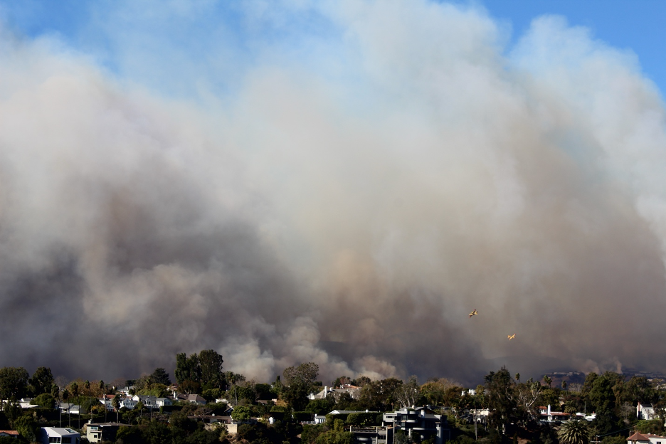
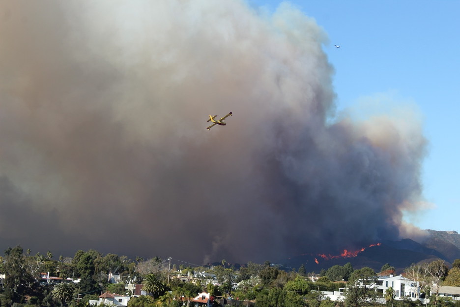
From Santa Monica, we could see that a small fire had erupted on a remote ridgetop upwind of Pacific Palisades before 11 am.The wildfire exploded and grew by the minute. The good news? To invade into Palisades neighborhoods (on the left), it would have to advance downslope, and fires usually burn much faster uphill.The bad news? It didn’t have to spread downhill. The Santa Ana wind was so strong, it carried and deposited burning embers up to a mile, starting several new spot fires far ahead of the original blaze.The blaze made noticeable progress within minutes, but responders were prepared. The air battle had already started.Within an hour, emergency messages were blaring out of our phones and people were gathering to watch the battle. But it quickly became clear that the wind and the wildfire were winning.Super scooper pilots braved what seemed to be dangerous winds and insurmountable odds. Sirens screamed in the distance as fire crews raced toward the growing inferno. By this time, the accelerating winds were blowing smoke plumes miles out into the Pacific.We could sense that this fire wouldn’t stop until it reached the ocean after burning through densely populated neighborhoods in its path.In desperation, fire crews had to focus on threatened neighborhoods while other flanks of the fire quickly spread out into the dry fuel. Some of these plant communities hadn’t burned in more than 40 years.Watch the super scooper in the distance as it skims over the ocean below the smoke plume, gathering tons of water to be dropped on the advancing flames.By about 3 pm Pacific Standard Time, Santa Ana winds had already blown the Palisades Fire smoke plume past the Channel Islands (lower center of this image), less than 5 hours after it started. Source: NOAA/National Weather Service.
If you want to experience the drama of escaping the Palisades firestorm and rushing to evacuate, check out Tracy’s series of photos and videos arranged in chronological order as escapees eventually make it down to PCH. The last images show an heroic officer using their hose to douse spot fires started by embers landing in their yard. Note how such a fire can advance with its burning embers through the sky faster than on the ground. (Please appreciate that these images are personal, raw, and unedited.)
Here is a time-lapse video showing the start of the Palisades Fire from another angle from 10:45am – 2:48pm. Thanks to NPS Ranger Susan Teele for sharing.
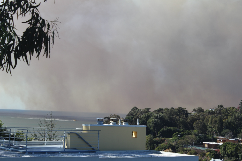
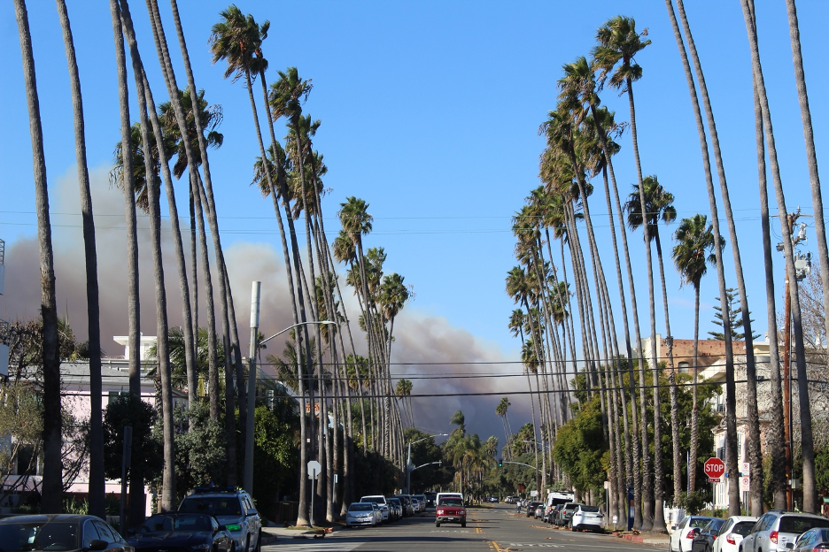
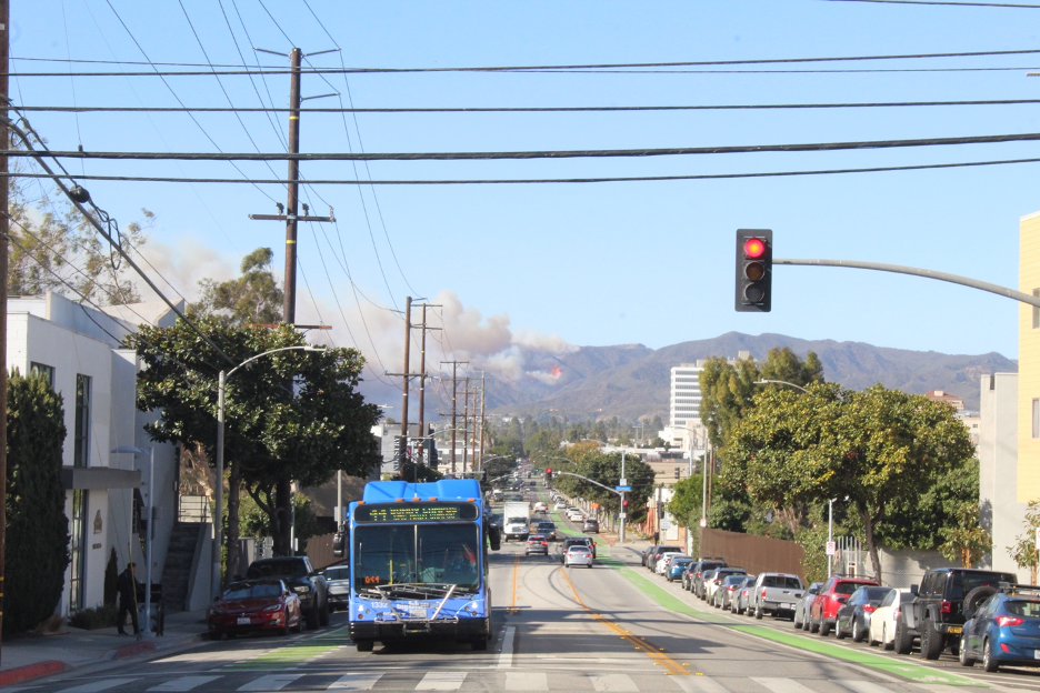
The advancing fire can be seen here from Santa Monica. Notice how Santa Ana winds are pushing the smoke plume and palm trees toward the ocean. Flames became visible from vantage points across the city.The Big Blue Bus shows how life goes on during this unimaginable first afternoon of fire. While Pacific Palisades neighborhoods were already being scorched, flanks of the fire would gradually expand until more densely packed urban neighborhoods were threatened. This is the flank that eventually spread several miles east (away from the coast!) into the Brentwood Hills, Mandeville Canyon, over toward the San Fernando Valley, and nearly to the 405 Freeway. Meanwhile, back at the base of the San Gabriel Mountains around Altadena, during late morning and that same fateful January 7 windstorm … Looking up toward the ridge, a roll of clouds condenses in ascending air and then evaporates in the descending air on the opposite side of the developing wave. That low pressure system dropping into northern Mexico (see weather maps below) was circulating just enough wraparound moisture to make it up to SoCal’s mountain ranges, but not enough to slow the terrifying wildfire that would erupt on these slopes later in the day. Photo by Matt Wright.
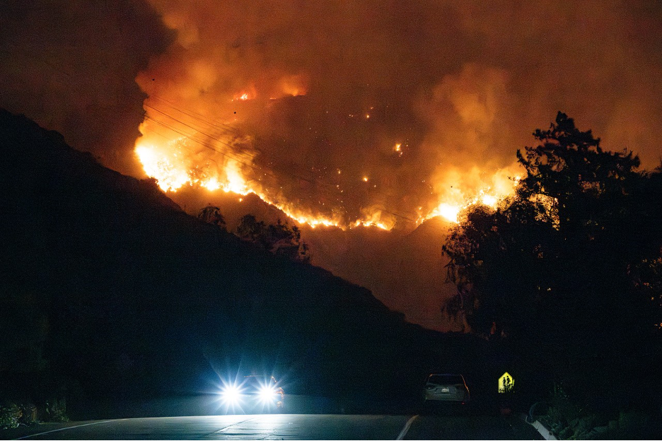
By that evening of January 7, fierce winds fanned sparks generated from near a homeless camp located below high-power lines (both common sources of wildfire ignitions) that spawned the Eaton Fire at the base of the San Gabriel Mountains. The blaze exploded and barreled down the slopes of Eaton Canyon. Blown by powerful winds, the inferno quickly raced into adjacent neighborhoods, destroying more than 9,000 homes, schools, businesses, and houses of worship. At least 17 people didn’t make it out in time. Photo by Matt Wright, just before their home was consumed.
This time-lapse video shows a Mt. Wilson view of the Eaton Fire from January 7-8. Another thanks to NPS Ranger Susan Teele for sharing.
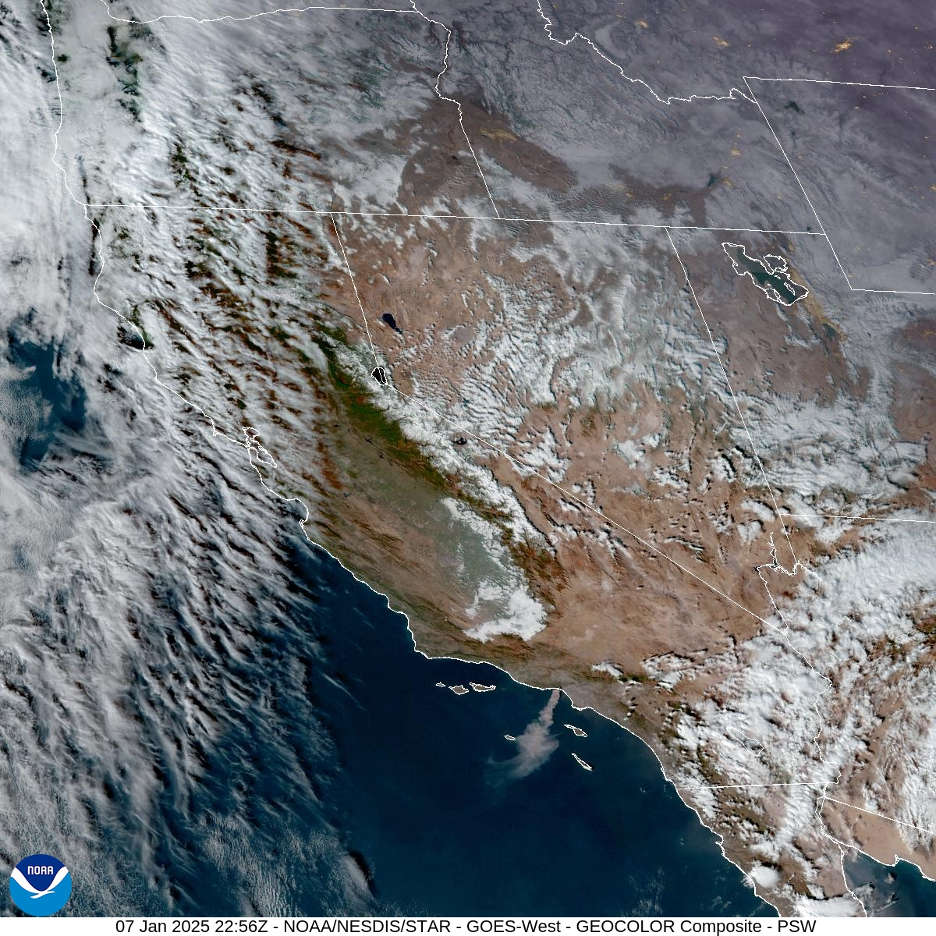
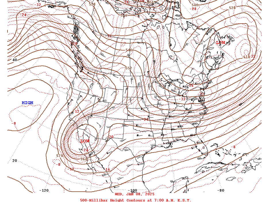
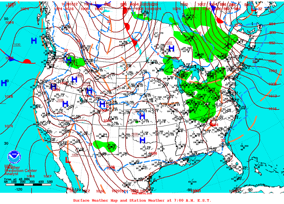
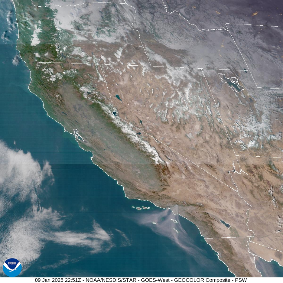
Back in Santa Monica … Offshore winds became so strong during the first two days of fire, they sheared off any smoke clouds that tried to billow higher. Notice (behind Santa Monica Pier) the turbulent eddies and swirls caused by friction and extreme turbulence flowing off of the mountains and out over the ocean. Those lighter high cirrus clouds are not associated with the fire and smoke.This 500mb map from January 8 illustrates how strong upper-level support helped to generate such powerful winds. Note the tight pressure gradient that has formed over Southern California between high pressure pushing in from the Pacific and deep low pressure that dropped into northern Mexico. Source: NOAA Weather Prediction Center.Surface map from January 8. A steep surface pressure gradient has also formed over Southern California between strong high pressure to our northeast and deep low pressure to our south, steering damaging winds to flow from the northeast and over us. Source: NOAA Weather Prediction Center.By the second and third days, unthinkable damage had been done in the Palisades as an eerie sickening veil of smoke settled over the area. Locations downwind continued to be threatened by burning embers. Slight changes in wind directions could have spelled disaster for any one of these neighborhoods.By the second day, smoke plumes from the Palisades and Eaton Fires (light brown streaks) were swirling in giant eddies hundreds of miles over the Pacific under the strong high pressure that helped generate those powerful winds. More definitive lighter clouds (not related to the fires) and Sierra Nevada snowpacks are also visible. Source: NOAA/National Weather Service.By day two, crowd control took over and evacuation zones advanced.
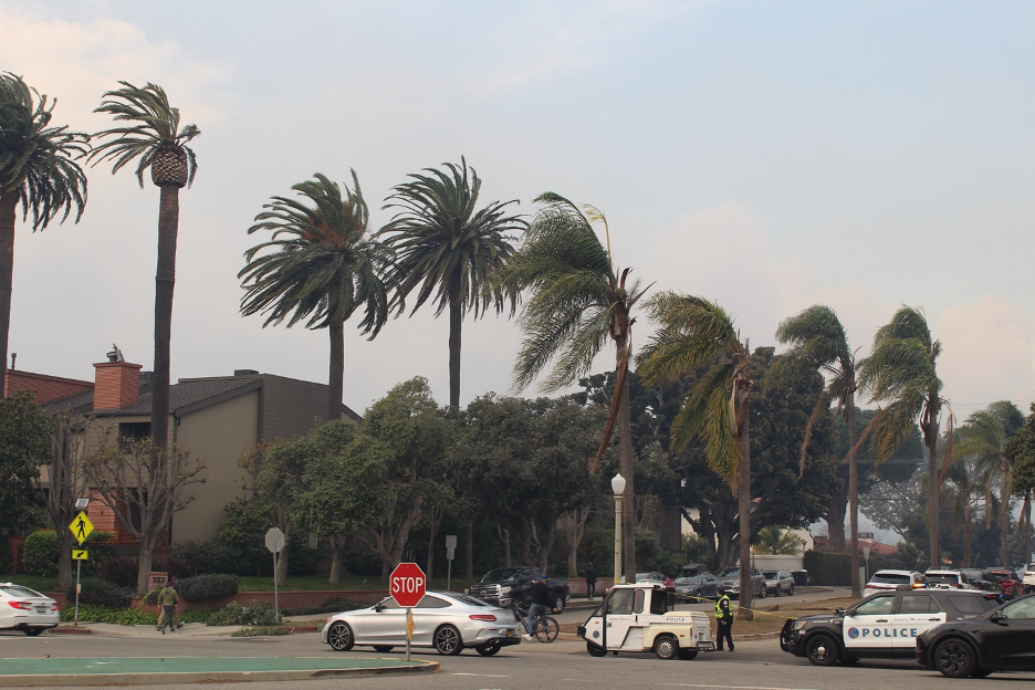
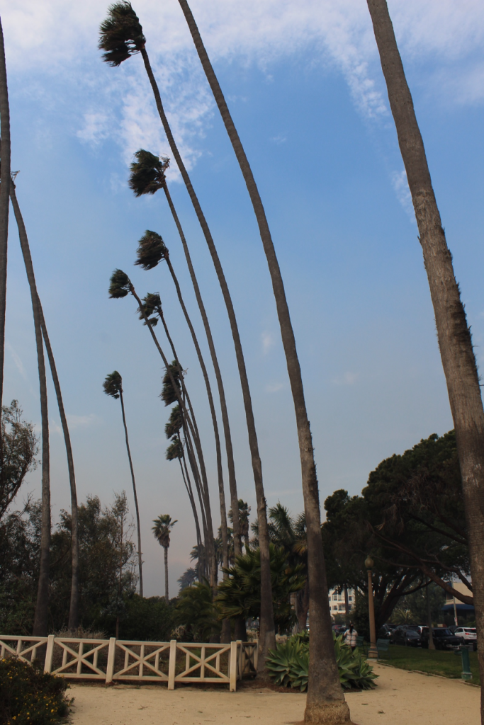
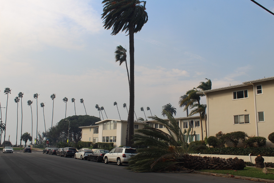
Strong Santa Ana winds challenged palm trees up on Palisades Park to stay anchored so they didn’t fly off to the beach. We are looking toward the fires and choking smoke.
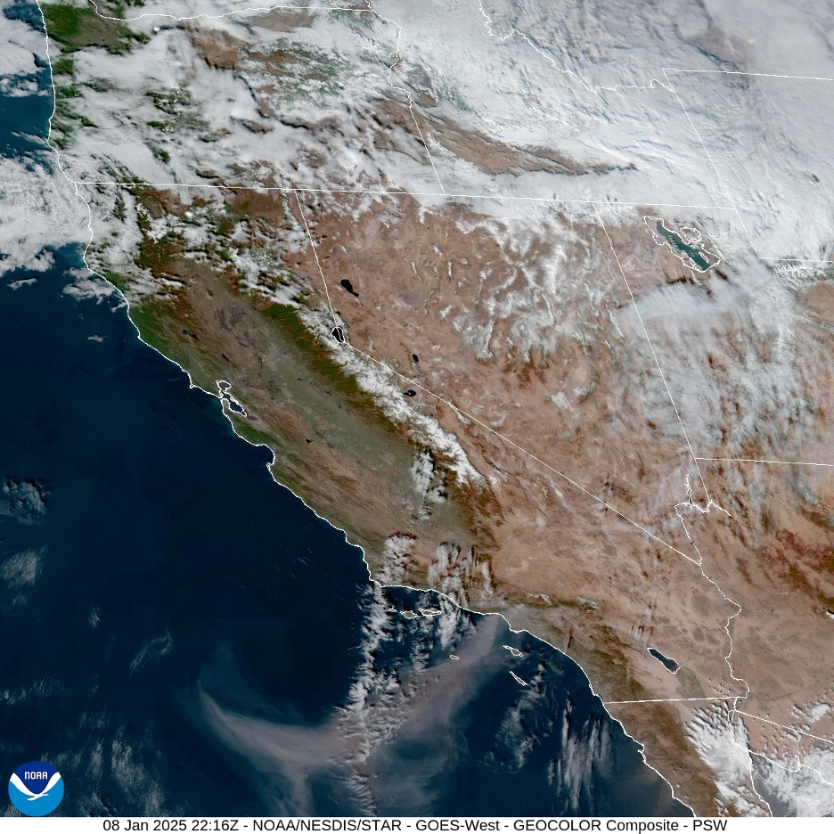
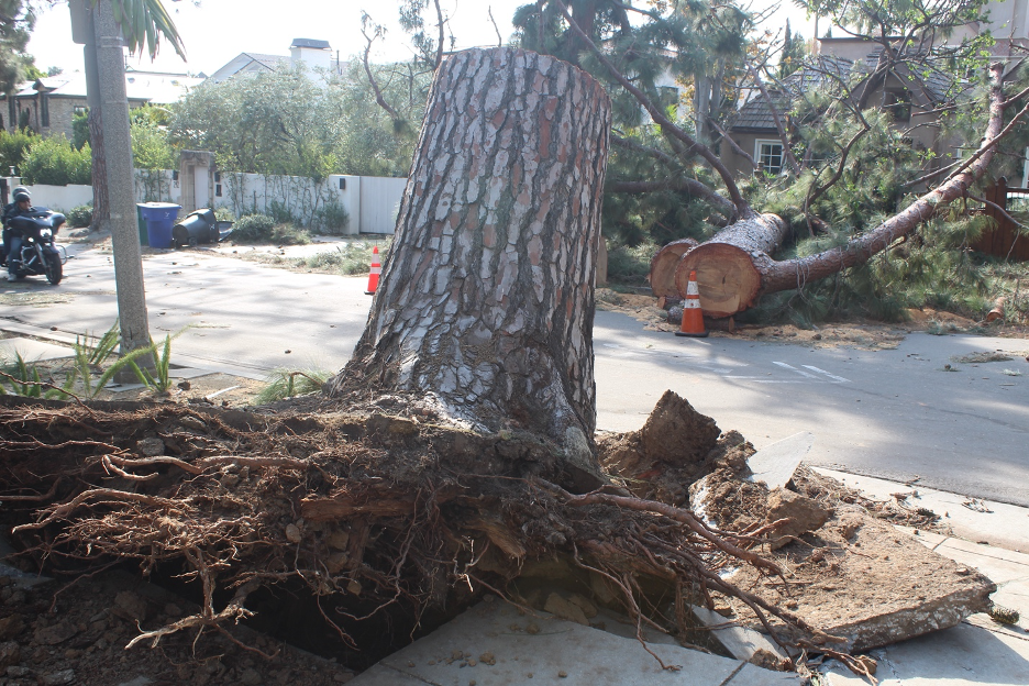
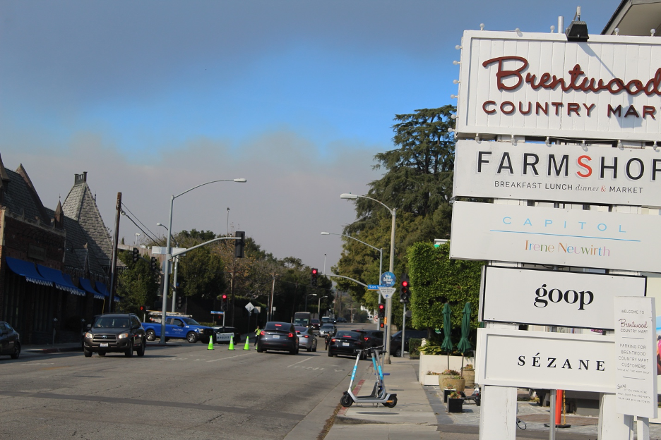
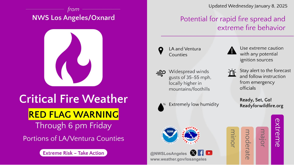
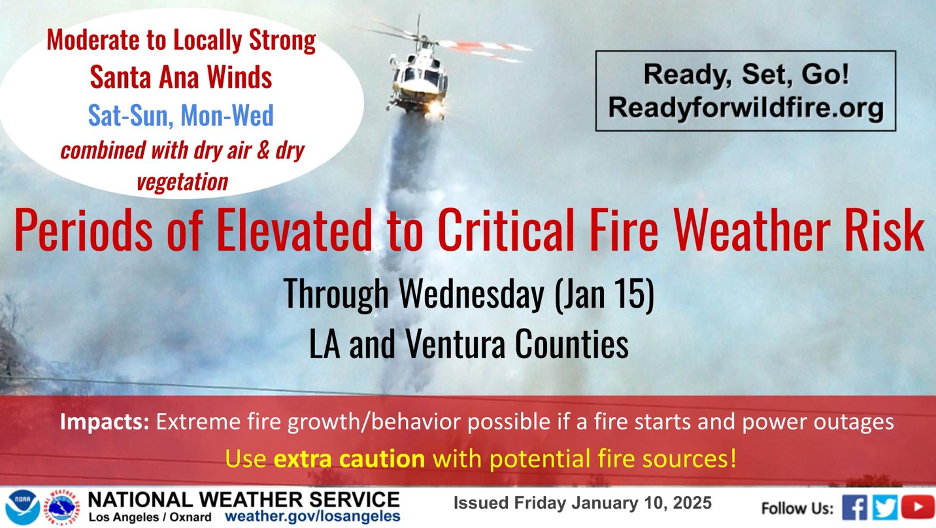
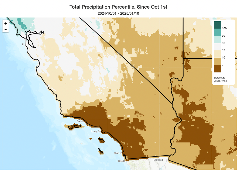
Some of the palms became victims of the vicious windstorm.Trees and power lines fell across the Southland, blocking roads, while locals talked of winds they have never imagined.The soil wasn’t even wet. How old do you think this tree was before it became another victim of this historic windstorm?Residents, workers, and business owners in some of LA’s most iconic districts (such as the Brentwood Village) kept nervous eyes on the advancing blaze and smoke as mandatory evacuations expanded all the way up to San Vicente Blvd. They got lucky this time around, but few ever thought that such danger could visit them here.Though winds finally began to subside, cautionary Red Flag Warnings extended through the week. By Thursday (day three), the Palisades and Eaton Fire smoke plumes were easy to spot on satellite imagery as they spread out over the Channel Islands and beyond. Source: NOAA/National Weather Service.As if we hadn’t had enough, this Santa Ana wind and fire story was far from over when the National Weather Service issued these warnings for January 11-15. Rain dance anyone?SoCal, we have a problem. Because data for this map starts on October 1 (our official water year), it doesn’t even show how this exceptionally dry period followed our summer dry season (since spring), which was also dryer and hotter than average. We’re now in our 9th straight month of prolonged dryness. Northern Cal already benefited from a very wet start to their rainy season (see our previous story on this website), so no drought problems—yet—there. Source: Weather West.
Notice how above-average precipitation quickly dwindles to far below average for this season as we move from Northern California to Southern California weather stations: https://ggweather.com/seasonal_rain.htm
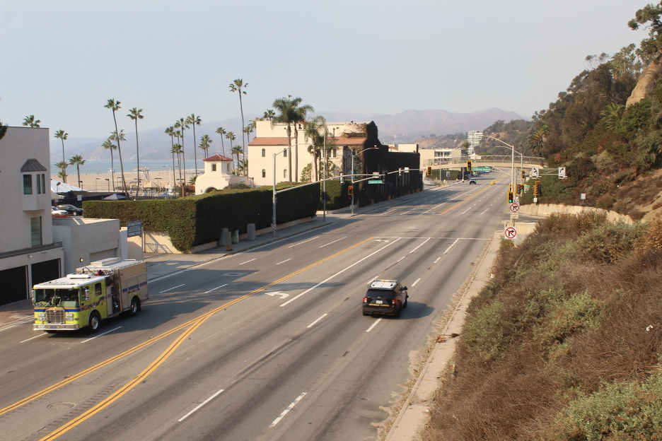
When do California’s playgrounds become forbidden land? Storied Pacific Coast Highway toward Malibu was closed to everyone except emergency vehicles. Fortified National Guard barriers helped to seal the evacuation zones. This is at the famed California Incline. It’s only 5 days after the cataclysm broke out, but most of the Palisades Fire has been reduced to a smolder. Compare this to the earlier view toward Santa Monica Pier (as the fire raged). Here, a welcome breeze out of the southeast pushed the smoke away, yielding relatively clear, blue skies. But the surfers who were riding gentle waves appear as absurdities when you look closely at hillslopes in the background. The formerly dark and light greenish-gray coastal sage, chaparral, and human settlements built in between have been charred into burnt remnants of the before times, all the way from Malibu to Mandeville.
Over many years, I’ve seen these signs erupt in too many communities in nearly every region across the western US. Few would have ever guessed this could happen along Santa Monica’s posh Montana Avenue shopping district, as it was precariously positioned on the evacuation boundary zone. Let’s hope this show is not coming to a community near you.
THE END??? All the stories on this website and in my California Sky Watcher book confirm what we’ve learned from experience: nature’s cycles never “end” and we’re just a part of them. Should it finally start raining in SoCal, the next chapters will likely feature catastrophic mud and debris flows that always follow these fires after they have stripped the covers off our hillsides. Stay tuned!
The Unimaginable Epilogue
Dominant upper-level high-pressure systems settled over the entire West Coast and generated exceptionally dry on-and-off offshore wind events across California for more than two weeks after the worst wildfires started. In Southern California, powerful Santa Ana winds howled through January 23, fanning numerous new fires just as crews tried to mop up some of the most destructive wildfires in California history. Relative humidity dropped into single digits throughout SoCal. But finally, for the first time since spring, weather forecasters were tracking a low-pressure system capable of delivering precipitation that promised to be the final blow to the fires by January 26. This little system wouldn’t direct any atmospheric rivers over the fire scars. We will have to wait to see if those will arrive during our other normally wet months of February and March. To learn more about the science and power of atmospheric rivers, you might check out my story about ARs on this website or read my feature article in the current edition of Weatherwise Magazine.
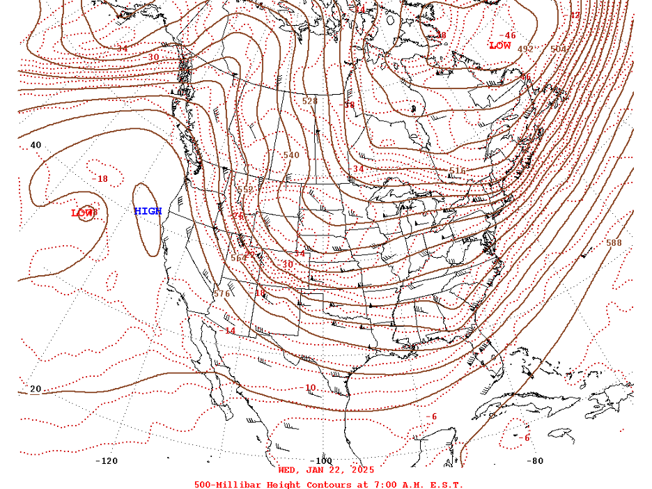
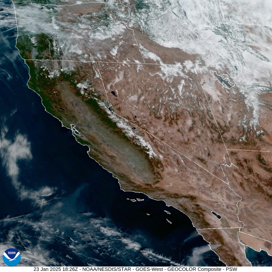
This 500mb map from January 22 shows the high-amplitude upper-level waves responsible for record-breaking January weather across the US. This resilient pattern remained stuck in place for several days. Following the pressure heights, you can see winds curving up and over that elongated high that dominated over the West Coast. The cold air then dropped down on the east side of the high and into the Great Basin, further enhancing strong offshore pressure gradients over Southern California. (Such exceptionally cold air masses also help explain why so many of this season’s Santa Ana winds felt “cool” even after the compressional heating.) Now follow those upper-level winds as they blast out of northern Canada and dip into the deep trough directly into the Midwest and southern states, carrying snow and a memorable deep freeze all the way down to the Gulf Coast. We can see how California’s record dry fire weather and the arctic blasts to our east were connected, all powered by these upper-level pressure patterns. Source: NOAA Weather Prediction Center.Strong high pressure keeps the entire West Coast mostly clear on January 23, 2025. It was just another day in the series of dry, gusty offshore wind events that dominated through most of the month. The winds blow two large smoke plumes into the Pacific from the latest wildfires in northern Baja California. Source: NOAA/National Weather Service.
Here are three videos shared by Karin from the Topanga Canyon Docents:
Topanga resident Elena Roche made a number of videos during the fire. You can see more on her YouTube site. Here, active fires were blocked just before they could burn through the community of Topanga and parts of Trippet Ranch. By this time, the fire fronts were spreading several miles around after ravaging the Pacific Palisades.
This video takes you up from PCH through Topanga Canyon in the aftermath to see what burned and what escaped the flames, and why any substantial rain will produce destructive mud and debris flows. It was filmed on January 17th.
Here are personal stories from the Topanga New Times published just before the first rain finally came.
The documentary Dry Times, made by Anurag Kumar and Alex Gregory, has, unfortunately, become more relevant as it captured California’s recurring predicaments during the megadrought that spanned more than two decades: Given recent events, this has become a haunting trailer. The Movie


Excellent article Bill! Crazy times we’re living in!
While others are trying to find scapegoats to pin the blame on, this article tells it like it is. Decades of overzealous fire suppression, the introduction of exotic species changing the fire regime, insane zoning code that allow construction in fire prone areas, and the increasing effects of anthropogenic climate change … and the band played on ..