Constantly evolving atmospheric performances are on display and calling out to us across our Golden State. This time, we demonstrate how one person can use photography to show the magic that erupts when art, atmospheric science, and landscape appreciation are blended together.
About the Photographer Matt Wright has been chronicling California since he borrowed his father’s 35mm camera for a junior high school photography class. Fifty years later, he has created a portfolio of the state, particularly Southern California, as it was and is. “Weather is a big part of the California experience, never mind the old Chamber Of Commerce bromides about sunshine, mild temperatures, and easy winters. The sun shines hotter, the winds blow stronger, and the storms are more dramatic than non-Californians imagine. Photographs bring dimension to the California climate story.” Contact Matt at mattwrightvo@gmail.com.
Following our Weather Past, Present, and Future Well said, Matt! Special thanks go to Marianne Wright, long-time President of UCLA’s Friends of Geography (FOG) Board, for making this serendipitous connection that now colors our web site. Here, we exhibit Matt Wright’s weather wonders, hoping that such aesthetics will attract visitors to learn more about the science behind the scenes. When you finish here, continue your sky dome journeys by viewing our previous weather story. Then, surf back to our earlier stories that address the changing weather patterns and climates across California during past months and years. You will find them peppered among our many other attempts to celebrate the geography of California. But this is just the beginning. During the coming months, we will be moving forward, introducing our exciting new project and publication designed to explore the weather and climate of our state.
Enjoy the show!
Blue Day. This panorama looks south from Pasadena and across the Los Angeles Basin. Signal Hill, Long Beach, and America’s busiest port are seen just in front of the shimmering Pacific. Catalina Island emerges behind them on the right, in the far distance. Unstable cumulus boil up into the cold air aloft. These clouds are part of a major November storm that slid down the coast, bringing record rainfall to parts of the state (for the date) and heavy snows to the Sierra Nevada and some other California mountain ranges.
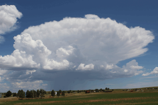
Boiling Towers. Sweeping to the southeast during the same early season November storm as in our last image, we look from Altadena toward Orange County and the distant Santa Ana Mountains. Cumulus congestus decorate the turbulent sky following heavy rains. They will float with the wind until they embrace nearby mountains, delivering some of the season’s first high elevation snow squalls.
Dazzling Light Show. A rare thunderstorm generates lightning to illuminate the San Gabriel Valley and much of southern California, 2021. Dominating high pressure, inversions, and stable marine layer air masses limit the average number of days with thunderstorms (as few as three each year) along stretches of the California coast. Brief invasions of moist, unstable air columns such as this are exceptions. Though cloud-to-cloud lightning is more common, this cloud-to-ground bolt gives us a chance to investigate the structure of the angry cumulonimbus cloud that sparked it. Contrast the updrafts, forming flat cloud bases in the foreground, with adjacent downdrafts in the background.
Sunrise, Eaton Canyon, Pasadena. Whether cirrus clouds are classified with colorful labels such as cirrus castellanus, floccus, or uncinus, they are all very high clouds made of ice. Their delicate ice crystals often form streaks, turrets, raggedy tufts, and comma-shaped fibers across the sky as they are blown with upper level winds. They can produce some of the most magnificent sunrises and sunsets when the sun is low enough on the horizon to illuminate their undersides that range above about 20,000 feet (6,000 meters).
Sunset, Arroyo Seco, Looking toward La Canada/Crescenta Valley. Layers of high, ice crystal cirrostratus spread and glide around 25,000 feet (7,600 meters) above sea level. During winter, they can warn of an approaching warm front. During any time of year, especially in southern California, they may be drifting over and around stubborn high pressure domes that block distant storms. At sunrise and sunset, most of the shorter wavelengths of ROYGBIV sunlight (violets, blues, greens, etc.) have been scattered and filtered out by a long trip though our atmosphere, leaving the longer wavelengths (such as oranges and reds) to illuminate the bottoms of the lofty overcast.
Summer Storm over Pasadena? What’s this? Unseasonable threatening skies above the land of summer weather stability? Summer storms are oddities anywhere above California’s coastal plains. This is certainly a most unusual scene to find along local trails.
Late Afternoon Clouds, Altadena. Puffs of high ice crystal cirrocumulus (above 20,000 feet (6,100 meters)) appear to merge together near the horizon. Higher clouds may seem to be stationary or move slower, but only because they are farther away from you. In fact, upper level winds that push the clouds are usually higher velocity, partly because they encounter less frictional drag than winds near the surface.
Cloudburst over Eagle Rock and the San Rafael Hills. Well-defined precipitation streaks in this downburst leave no doubt which landscapes are being soaked by this storm.
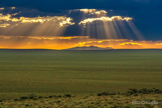
Sunset through Clearing Storm, Arroyo Seco, Pasadena. The sun’s rays poke through clear spots in broken cumulus congestus and more distant cumulonimbus. These crepuscular rays only appear to converge toward the sun as they are farther away from us. They shine through moisture and various air particles, producing such optical phenomena as seen from our perspective. You can thank the remnants of Tropical Storm Kay (covered in previous stories on our web site) for producing this spectacle.
Looking Down toward a Summer Afternoon Haze. We are viewing across the L.A. Basin, toward the Palos Verdes Peninsula, with Santa Catalina Island in the far distance. From the chaparral-covered San Gabriel Mountain foothills, we can see how downtown skyscrapers and hills in the region pop up above the cooler, hazy marine layer settled only a few hundred feet deep near the coast. These conditions in California usually signal a strong high pressure system aloft. Air parcels descending from the upper-level high are heated by compression, capping the shallow inversion with a hot, dry air mass. Fog can be seen over the ocean, but the relatively cooler, stagnant surface air also concentrates pollutants over the land that can produce some of our worst air pollution episodes. Note the higher clouds that are not associated with the inversion or marine layer.
Clouds over Mill Creek Canyon, Angeles National Forest. These orographic clouds form in waves of otherwise stable air parcels that are forced to ascend, cool, and condense as they glide over the mountains. The air streams then return to preferred lower altitudes downwind (on the backsides) of the ridges. The result is a tablecloth-like cloud draped over and reflecting the topography of the very mountain range that helped configure it.
Winter Storm Clearing, Mt. Baldy. Single winter storms can dump snowfalls measured in feet at higher elevations, even in southern California. Unstable cumulus and stratocumulus often chase one another behind cold fronts after the storms pass south and/or inland. These orographic clouds form when cool, moist air masses flowing behind the exiting storms are forced to rise over mountain barriers, where the unstable air will further cool to its dew point.
Blue Moon setting over San Rafael Hills, Pasadena, 11-1-20. Looks like the clouds parted just in time.
Afternoon, Dana Point and Capistrano Bay. As previously noted, such heavenly crepuscular rays don’t really converge toward the sun. But you can see why they rank high among nature’s most worshiped optical phenomena.
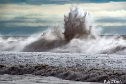
King Tide Augmented by Baja Storm, Capistrano Beach, 8-21-21. Beaches along the southern California Bight are particularly vulnerable to swells from the south and southwest during our summer months. Such powerful waves may be generated by tropical storms off Mexico or from southern hemisphere’s middle latitude wave cyclones during their winters. Follow this wave ashore as it wreaks havoc in the next image.
Coming Ashore. The untimely arrival of such high surf on top of an already high tide results in severe beach erosion and damage to structures built too close to the breakers.
Overcast, Capistrano Bay. One sunshaft, through one break in a thick marine layer low stratus deck, forms the background for one surfer. You can always surf back to our earlier web site story about surfing when you are done surfing here.
Incoming Storm from Hwy. 18, across the Transverse Ranges. A rich mix of high cirrus, middle, and low stratocumulus clouds decorates this sky dome, evidence that all layers of these air columns are moistening up.
Clearing Storm, Santiago Peak, Orange County. It looks like the front has just passed, but residual moisture streaming behind it is lifted over the Santa Ana Mountains. Orographic clouds form as the air parcels are forced to rise and cool to their dew points.