Page 2: More Detailed Definitions and Explanations
(1) Winter storms are often labeled “inside sliders” when they enter the continent far to our north, expend most of their moisture, then follow a path over drier land surfaces, often dropping down the back side of the Sierra Nevada Mountains or through Nevada. They are usually cold, but moisture starved as they pass to our east.
Another Dry Winter. January and February are usually the wettest months in California’s rainy season. Not so much this year. On this (January 16) 500mb chart (halfway through the atmosphere) and satellite image, you can see the enormous upper-level blocking high pressure ridge anchored off the coast. Winter storms ride to the north, up and over the high, bringing only a few showers to northern California. Record high temperatures across the state topped 90 degrees F (32 C) in southern coastal valleys. Similar winter patterns finally left the state in another drought. Source: NOAA/San Francisco State University.
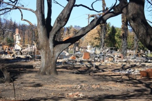
This is What Drought Looks like. Too many rainy season days looked like this in January, 2021 as high pressure drove approaching storms north and over the state. Source: NOAA/National Weather Service.
(2) High pressure domes that caused record heat in June and July were also responsible for trapping smoke from the wildfires. Dense, heavy air masses were heated by compression as they descended out of the tall stacks of high pressure. The smoke was trapped and baked within the stable, stagnant air masses capped below these stubborn high pressure systems. Relief would only come from strong winds that could push the smoke into other states or from low pressure systems and storms that could destabilize and mix the air, diluting and dispersing the smoke. The brighter clouds over southern California are connected to the monsoon moisture streaming out of Arizona. Source: NOAA/National Weather Service.
(3) Wildfires not only send up extraordinary clouds, but the larger fires create their own weather. Air expands in the extreme heat, causing the smoke to rise and billow into pyrocumulus clouds. Surrounding air is sucked into this super-heated, low pressure tempest at the surface, generating powerful wind gusts that fan the flames. Fire twisters, sometimes called “firenadoes” add to the drama. Within the violent updrafts, smoke particles act as condensation nuclei, which attract available moisture. As condensation accelerates, latent heat is released and the cloud grows taller into a smoky towering cumulus. Clouds billowing over larger fires may grow to become cumulonimbus flammagenitus, or giant thunderheads with frequent lightning and even cloudbursts that can briefly douse parts of the fires. These clouds can grow to over 30,000 feet asl (9,144 m). Too many Californians have observed these awesome spectacles more than once during recent years. Many more Californians have suffered health problems form breathing layers of dense smoke trapped and circulating below air columns descending out of high pressure systems.
Another Familiar Sign. Here’s yet another informative sign that could be found in any western state. It reminds us that scientists and firefighters are working to better understand how more frequent and devastating wildfires fit into the natural systems and cycles that shape our ecosystems, especially in these times of unprecedented and accelerating changes.
Educating the Public. This National Park Service Ranger is helping visitors in Glacier National Park understand the importance of natural wildfires and how climate change and other human impacts may be altering their frequency and behavior. Unfortunately, the scenery is obscured by smoky haze drifting from California and other wildfires in July 2021. But, she could be working at any national park in California or beyond its borders since every landscape is being impacted, illustrating how we are all in the same boat.
“Dixie Fire Map. The red line was the perimeter at 9:45 p.m. PDT Aug 9, 2021. The yellow areas represent intense heat. Not all of the fire was mapped due to the massive smoke plume up to 22,000 feet.” Taken from Wildfire Today, USFS/CAL FIRE. (This fire had grown to more than 600,000 acres by mid-August.)
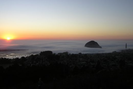
Reversing the Wind. By August 18, 2021, an unseasonable cutoff low spun out of the Pacific Northwest toward Utah. Counterclockwise circulation around this disturbance, which resembled a colder fall, winter, or spring system, reversed wind directions seen on our previous satellite images. Here, you can see northeast winds in northern California pushing the smoke offshore and to the south. Though cooler, these gusty winds hampered firefighting efforts, fanned new fires, and challenged exhausted fire crews. (An exceptionally deep marine layer covers southern California coastal valleys. This is another indication that summer’s relentless high pressure and heat waves have at least temporarily been replaced with lower pressures and cooler temperatures over California and other western states.)