Eastern Sierra Nevada and Basin and Range Clouds and Storms: August, 2022
Summer Thermals. Cumulus clouds commonly condense to decorate afternoon skies above the mountains surrounding the Owens Valley during summer. The high desert surface, with its ancient basaltic lava flows and other volcanic features heated by intense sunlight, warms boundary layer air parcels. Expanding and rising thermals are given a boost as they must glide over the adjacent heated mountain slopes. During July, August, and September, when the Four Corners High expands or moves closer, summer “monsoon” moisture sometimes circulates out of northern Mexico, southern Arizona, and Nevada, invading high desert terrain east of the Sierra Nevada and into the Basin and Range. These landscapes are normally stuck in the dry rain shadow during most of winter, when powerful storms are dumping snow measured in several feet and meters on the west slopes and ridges of the Sierra Nevada behind us. In contrast, summer weather patterns may deliver brief invasions of moist summer monsoon air masses that usually have greater impacts on these Basin and Range landscapes east of the spine of the Sierra Nevada.
Waiting for the Rain. Dry pinyon-juniper woodlands are commonly found at higher elevations in the White and Inyo Mountains above the Owens Valley. They contrast with similar elevations in the western Sierra Nevada that receive copious orographic precipitation during winter and accumulate heavy snowpacks beneath much lusher forests. In contrast, when pressure and circulation patterns briefly become favorable, these dehydrated rain shadow slopes are sometimes situated within the bullseye for brief summer invasions of moisture form the southeast. On this day, there’s just enough moisture to build some cumulus in the afternoon thermals; but we are too far west of the monsoon to expect a storm. We will have to wait for a wetter pattern to develop tomorrow.
Hot, Dry Weather Patterns. In this August 14th 500mb map, note how the massive high pressure across southern states extended all the way over California. These tall stacks of dense, heavy atmosphere descended and compressed the air over us, capping and thwarting any convection that may have tried to develop during scorching afternoons. Source: NOAA/National Weather Service.
Teaser Storms? No storms are expected on this bright August afternoon in the White Mountains. We are looking southeast toward wetter monsoon air masses in the distance. Such Southwest Monsoon storms are more common farther southeast, into the flow of moist air from northern Mexico and Arizona. Even these distant pop-up cumulonimbus can’t build high enough to form soaking or severe storms, as upper- level high pressure overhead squashes air masses and limits convection. We’ll have to wait for patterns to change tomorrow.
Atmospheric STEAM on Display. This bag of vegetable chips was purchased at a store close to sea level, where the average atmospheric pressure is measured around 14.7 lbs/sq. inch, or 1013 mb. Here, we have travelled up into the White Mountains at about 10,000 feet (~3,000 meters) above sea level, where average air pressure averages around 10.1 lbs/sq. inch, or 700 mb. The greater sea level air pressure is attempting to explode out of the sealed bag and expand into the lower atmospheric pressure in the rarified (thinner, less dense) mountain air surrounding the bag. Opening the bag ends this experiment. Summer afternoon air parcels of heated air ascending over the mountain slopes will cause those unsealed parcels to freely expand and cool. If there is enough moisture in the air, they will cool and finally condense after reaching their dew points. A cumulus cloud may form above each rising thermal.
Clouds Line Up over Mountain Crests. Lines of afternoon cumulus clouds first pop up as summer air is forced to rise over the crests of Basin and Range mountains. When the cumulus condense and grow early and abundant moisture streams up from the southeast, isolated to scattered thunderstorms, cloudbursts, and local flash flooding may result. Insufficient moisture and a more stable atmosphere will inhibit such storms from forming on this day. Lines of harmless cumulus décor have formed above the bristlecone pines here in the White Mountains and over other distant mountain ranges, while large patches of clear blue sky appear above the desert valleys between mountain ranges, as we look toward Nevada.
More Teasing Skies. It’s already late afternoon, as we view through some of the oldest trees on the planet (Pinus longaeva, or Bristlecone Pine), toward clouds threatening to grow into towering cumulus congestus. But it is too late in this day’s atmosphere that lacks sufficient moisture and instability.
Water and Energy Cycles in our Atmosphere. A closer look reveals how flat cloud bases form at condensation levels (when rising, expanding air cools to its dew point). This process (when high-energy water vapor condenses to lower-energy liquid water drops) releases latent heat within the cumulus clouds, encouraging them to boil higher. (Such latent heat helps explain why cumulus grow those puffy tops; such liberated latent heat also fuels major storms throughout our atmosphere and around the world.) The water drops form around condensation nuclei or freeze around freezing nuclei to grow into larger ice crystals higher in the cold cloud. They may eventually attract enough moisture to grow large enough to fall through the clouds toward the surface. You can see this happening in the distance. However, these streaks of potential precipitation are evaporating in dry air at lower elevations, defining the term “virga”. This will limit any precipitation, on this day, to a few higher elevation sprinkles.
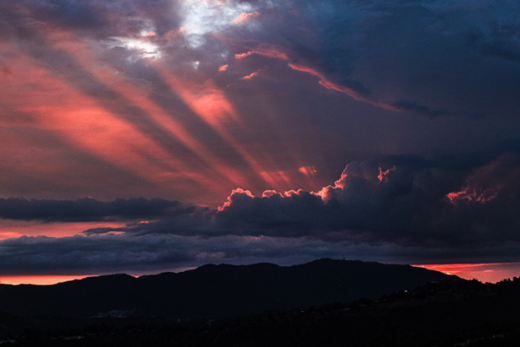
Collapsing Dreams of Rain. As night approaches in the White Mountains, the slopes cool, cutting off the afternoon’s once promising updrafts. Clouds begin to dissipate and only a few collapsing cumulus and their distant colorful downdrafts with virga are illuminated by the setting sun.
Clearing Skies, but Promises for Tomorrow. As the moon, Jupiter, and stars rise over our camp in the White Mountains, clearing continues, opening our sky dome to some of darkest night skies and best star viewing in the Golden State. Lunar crepuscular rays soon appear to radiate out from the horizon. This moonrise would become our bright flashlight for the night, but it would also wash out our dark night sky views. These distant debris clouds, along with some very distant lightning flashes, were seen toward the southeast, marking the boundary of wet, unstable monsoon conditions that were soaking parts of Arizona. An increasing southeast flow would expand this wetter boundary over us during the next two days.
Monsoon Moisture Moves Closer. By the next day, the Four Corners High had shifted and expanded a little farther west. Advection of moist air from the southeast encouraged cumulus to grow in the invigorated afternoon thermals. As we moved farther north and up toward Sierra Nevada high country, distant showers and a few isolated thunderstorms seemed to chase us as we viewed toward the southeast. After we set up camp at Tioga Lake (nearly 10,000 feet (3,000 meters) above sea level), we were treated to another spectacular sunset. This time, the setting sun illuminated evening downdrafts from dissipating storms carrying isolated showers that made it to the surface, particularly at higher elevations. On the Edge of Stormy Weather. This 500 mb pressure map from August 17 shows how that massive upper-level high pressure system over the southwest has shifted slightly. Clockwise flow will usher moist, unstable monsoon air masses from the southeast into eastern California. As usual, coastal California remains just west of the high and its monsoon flow. Source: NOAA/National Weather Service.Spotty Clues of Future Storms. The next morning’s altocumulus were drifting from the southeast, displaying how moisture and some instability had spread into the Basin and Range and over the Sierra Nevada overnight. All it would take was some afternoon heating on the slopes to lift thermals into the moist air. Reflecting Future Turbulence. Runoff into Lundy Canyon (on the eastern slopes of the Sierra Nevada) met a beaver dam, resulting in this pond. Flooding waters killed the riparian trees long ago, but served to reflect the same altocumulus that would warn of the turbulent weather to follow later in the day. We can blame the beavers for building the dams that filled their ponds and drown the trees, but thank them for backing up water windows to reflect our clouds.
Downburst Dust Storm. By the afternoon, cumulus had built large enough to produce showers and a few weak storms in the moist summer air mass. But high pressure aloft squashed the air columns and discouraged the clouds and their storms to grow up to very high altitudes. As their anvil tops quickly levelled off and drifted with upper level winds, debris clouds soon covered the entire region. This blocked sunlight and cut off what would have been stronger updrafts that could have fueled larger, more violent summer convection. A few storms grew large enough to produce brief strong downdrafts and very localized downpours. Here, one of those downdrafts becomes a microburst of cold air racing out of the clouds and blasting across the high desert floor. As the strong outflow passes across the shores of Mono Lake, it kicks up dust clouds from the exposed salty shoreline.
Streaks of Heat Relief. A line of weak storms and showers poke through middle level clouds toward the distant Sierra Nevada Mountains. Again, these August afternoon build ups don’t display impressive vertical development in the relatively high pressure and stable atmosphere of this day. Rainfall totals were just as unimpressive at locations lucky enough to receive some relief from summer’s heat. The next day’s weather would be more turbulent.
Storied Weather Station? Instruments in the weather shelter at Bodie often measure the coldest temperatures in California. This may include the coldest overnight low temperatures (more than 50 times/season) in the contiguous U.S., mostly around and during the summer months. Extreme seasonal and diurnal variations in temperatures are common in this most famous high desert ghost town east of the Sierra Nevada. The dry, rarified air at this location above 8,370 feet (2,551 meters) lets intense radiation in during the day, but allows the heat to quickly radiate out at night. It is also located in a small valley where cold air drains, settles, and pools around the ghost town during calm nights. On this August afternoon, debris clouds fill in between the unusually moist and saturated updrafts and downdrafts.
Behind the Door Where Weather Records Fall. Weather station shelters such as this one were more common long before the days of automation and more advanced technologies. The white enclosure reflects sunlight and the slats are angled and spaced to keep precipitation out, but allow breezes to flow freely through the shelter. Alcohol or mercury liquid-in-glass maximum/minimum thermometers measure and mark the high and low temperatures for each day. Resident Bodie State Park Rangers are trained to regularly visit the shelter to make official readings, regardless of punishing weather extremes. Newer, smaller electronic thermometers (known as Maximum Minimum Temperature Systems (MMTS), or thermistors) are replacing many of these larger shelters, so the days may be numbered for this Bodie tradition.
Stormy Desert Skies. Since it rests in the rain shadow of the lofty Sierra Nevada, the ghost town of Bodie averages only about 13 inches (33 cm) of water-equivalent precipitation per year, which is less than Los Angeles, far to the south and near sea level. However, most of Bodie’s precipitation falls as snow (around 100 inches/yr. (254cm/yr.)) during winter storms and much of the powdery snow pack sublimates into the dry, thin air. On this exceptionally moist August afternoon, ascending updrafts expand, cool, and condense to build clouds with dark, raggedy bottoms that coalesce. Adjacent downdrafts appear as less defined foggy streaks.
Rare Rain in a Dry Ghost Town. Later on this darkening, increasingly-angry August afternoon, the building clouds have expanded and become more unstable; precipitation processes form aloft and downdrafts carry brief but beneficial summer showers to the dehydrated desert sagebrush surface. This day’s summer weather pattern seems to resemble the southwest monsoon of Arizona. Dueling aromas erupt from the moistened soils, plants, and the historic buildings that date back to the 1880s. How many more weather events might these deteriorating, leaky structures, housing the ghosts of Bodie, withstand before they are finally weathered away? Back at Mono Lake. Late afternoon summer showers continue dancing around Mono Lake. But the buildups quickly level off and spread out under relatively stable high pressure. The clouds then block direct sunlight that would otherwise warm the surface and destabilize air columns. As the sun sinks toward the horizon, this August day will end with little accumulation of the spotty precipitation, followed by collapse of the modest updrafts and dissipation of the clouds and showers. But even the more rare, larger summer thunderstorms are not significant sources of water for the region’s larger streams and lakes. Like Mono, they are mostly recharged by runoff from the annual melting snow packs in the high Sierra Nevada.
Danger over Elizabeth Lake. We start the next morning in Yosemite’s high country, with a hike to Elizabeth Lake at about 9,500 feet (2,896 meters) above sea level. Shifting high pressure overnight has enhanced winds from the southeast, advecting more moisture and instability into the region. An early thunderstorm forms upwind, feeds off thermals rising from heated mountain slopes, and drifts northwest in the prevailing winds over the lake. Such weather patterns may deliver precious moisture to mountain soils dehydrated by summer drought. But at these elevations, a severe storm can suddenly turn a pleasant hike into a miserable, soaking battle to avoid lightning strikes and hypothermia.
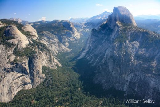
Updrafts over Tuolumne Meadows. As the day progressed, stronger updrafts glided over mountaintops around Tuolumne Meadows. The rising, expanding air parcels cooled to their condensation levels, forming jagged, but well-defined cloud bases. Tremendous amounts of latent heat were released as water vapor changed phase to liquid water drops, causing towering cumulus to boil and merge into ominous cumulonimbus. Here, the glaciated granites of Lembert Dome point toward growing storms.
August Thunder Delivers. As summer afternoon storms built and danced over the peaks around Tuolumne Meadows, large ice crystals grew in higher updrafts. The Ice Crystal Process produced, and downdrafts delivered, hail and large, recently-melted water drops to the ground. Here, Lembert Dome points toward some of the stronger updrafts (with well-defined cloud bottoms) and adjacent downdrafts (with fuzzy, nebulous steaks and columns pointing down) that are common in developed thunderstorms. The thunder rumbled around the meadows until cold precipitation cooled and stabilized higher slopes. Then, the storms converged on the relatively warmer meadows, bringing heavy cloudbursts and frequent lightning. As the sun was finally setting, updrafts that fueled the storms ceased and dying downdrafts were left to dissipate the storms and clouds.
Disappointing Summer Falls. After all the August thunderstorms and isolated local flooding drama in the high country, some would be surprised to find that lower elevations in the Sierra Nevada (such as in western foothills and Yosemite Valley) remained relatively warm and dry. Temperatures ranged from the sopping 50s high in Tuolumne Meadows to the dry 80s and 90s down in Yosemite Valley at the same time on the same afternoon. Only occasional clouds and distant thunder threatened in the valley. The scene and the sign remind us that Yosemite Falls (hardly trickling in the background) and other Sierra Nevada streams and rivers are fed mainly by runoff from winter’s storms and melting snow packs, rather than those brief and localized summer afternoon thunderstorms.
Morning Steam: Yesterday’s mountain storms collapsed and their debris clouds dissipated overnight, allowing already chilled surfaces to radiate out even more heat and cool faster. The chilled air parcels then drifted over Tioga Lake (elevation more than 9,600 feet (2,926 meters) above sea level). But the lake is still relatively warm after absorbing a long summer’s heat energy. As water evaporates off the lake surface, it saturates overlying cold air that has a low capacity to hold water vapor. The result: wisps of steam fog drift above the lake until they mix and evaporate into the drier air.
Sun through the Steam. The steam fog drifts away from Tioga Lake with prevailing breezes that have changed direction overnight. Sunlight will eventually warm surrounding surfaces and air parcels above their dew points, evaporating the fanciful morning fog.
Tufa Towers Point toward Promising Puffs. On the morning following the soaking summer storms, high pressure has shifted again to direct drier air masses into the region. Still, residual moisture forms puffs of potential cumulus towers in thermals that rise above Sierra Nevada’s warming high country slopes. Today’s forecast calls for only a slight chance of an isolated afternoon storm around Mono Lake. We are looking west toward Sierra Nevada’s uplifted rock formations; they represent the most massive and efficient of the topographic barriers that block winter’s wet storms and other Pacific air masses from reaching this high desert rain shadow terrain. We will visit the central coast on our next page.
Rising Towers. A boiling cumulus seems to mimic Mono Lake’s tufa towers, except the towering cloud is being sheared to the right by shifting winds off of the Sierra Nevada. Several of these summer cloud formations would form and dance through the sky as thermals increased throughout the day. But none of them could organize or grow large enough to match yesterday’s storms.
Water Going up and Falling Down. Rainbow Falls drops water that accumulated during previous precipitation events of yesterday or yesteryear. There is not enough moisture or instability for these building cumulus to get any larger today, so they will never contribute to stream flow here around Mammoth Lakes and Devil’s Postpile.
Some Summer Shade on a Scorched Mountain. Though afternoon cumulus clouds may not deliver precipitation on this August day, they are welcome summer shade makers. This is especially true in this landscape that was incinerated just 20 years earlier by the Rainbow Fire. The massive wildfire was ignited by lightning generated during August thunderstorms that lacked sufficient precipitation to douse the flames. Strong winds blew spot fires that threatened within 3-4 miles of Mammoth ski resorts. This is what twenty years of forest recovery looks like in this land of heavy winter snows and mostly dry summers. Mammoth Mountain towers in the distance; it will have to wait a few months for winter’s snowstorms that will attract skiers and snowboarders from around the world.
Flat Bases and Puffy Tops above Dehydrated Earth. Rain shadow landscapes east of the Sierra Nevada stretch east from Mammoth Lakes, across the Long Valley Caldera, into the lofty White Mountains in the far distance. Cumulus congestus merge together, but this will be the peak of today’s summer afternoon cloud build ups that struggled to only sprinkle brief, isolated light showers on the highest peaks in the region. Another long, hot dry spell is in store for this harsh high desert terrain in the coming weeks, still a couple of months before drastic cooling that will signal the autumn season.
What will autumn bring to the landscapes of this region? Skip several pages back on our web site to find our story, Searching for Autumn Colors in the Eastern Sierra Nevada.
Before moving on, click to our next Page 3 here; we will transport you to strikingly dissimilar cool, stable central coast weather patterns and landscapes during the same August of 2022. Though they are just 200 miles west, they will seem worlds apart from our eastern Sierra Nevada.