Central Coast’s Stable Marine Layer: Summer of 2022
Contrasting Weather and Landscapes. Pelicans and people experience a drab, stable August chill under a stubborn marine layer. Pismo Beach displays a dramatic contrast to the scorching inland valleys just several miles east of here and the big sky eastern Sierra Nevada landscapes and weather patterns we just explored on Page 2, only about 200 miles to the east. So many visitors who came to this coast to escape summer heat have found what looks and feels like another season. Many do not know that warm, clear, blue skies are common once we poke through the flat inversion layer that caps this muck, often only about 1,000 feet (300 meters) above sea level.
Flat Seas Mirror Flat Ceilings. Dark low clouds and fog often blanket these central coast beaches during summer months, but it is usually perfectly clear just above the stratus. First-time visitors may be deceived by the ominous, gloomy spells they can cast. But locals and regulars know that the marine layer’s flat innocuous gloom is a sign of monotonous mild and fair weather stability that lasts throughout their typical summers without storms. Pitifully insignificant waves indicate how summer’s calm stretches far out into the Pacific. The dark blanket only attempted to burn off on this August afternoon, teasing those who dreamed of sunnier days around Pismo Beach.
Thinning Fog Exposes an upper Atmosphere Show. On the next day, looking toward Avila Beach, strengthening high pressure aloft sent descending air masses that squashed the marine layer. The shallow fog was further evaporated and thinned from above by the afternoon sun’s heat and from below by radiation emitted by heated surfaces. This orchestrated the daily summer weather routine: late night and early morning low clouds and fog, otherwise mostly sunny during the afternoons. The low-level clearing exposed high- and middle-level clouds circulating between high pressure to the east and lower pressure out at sea. More than 15,000 feet (4,570 meters) of clear vertical air columns separated the low fog from the middle clouds and even higher decorative ice crystals.
Evolving Atmospheric Science Experiments. This afternoon around Port San Luis featured the typical battle between the cold, saturated sea breeze and the afternoon heating that raises air temperatures above the dew point, causing the fog to evaporate. Such daytime heating thins (or “burns off”) fog layers until sunset, when the air will again cool below its dew point, allowing the fog and low clouds to condense again and cast their flat blankets across the coastline overnight. Strata Meet Stratus. Horizontal layers of relatively young shale have been lifted by tectonic activity and eroded by wave action at Montana de Oro. The shallow, stable, horizontal marine layer casts fog and low stratus that often glides up coastal slopes to cover these landscapes, especially during summer nights and mornings.
Coastal Sage Scrub in the Fog Belt. Along the marine terrace trails at Montana de Oro, we see coastal sage scrub that thrives under summer’s marine layer. Annual rainfall totals near the beaches are lower than on the mountain slopes just a little farther inland, which benefit from orographic precipitation. But when winter’s rainy season ends and summer’s drought drags on, cooler temperatures, higher relative humidities, and some fog drip slows evapotranspiration rates near the ocean. These conditions support our “soft chaparral”, low-growing, coastal sage scrub plant communities. Buckwheat and coyote brush (seen here), and California sagebrush are among the plants that compete along these coastal strips that rarely experience hot summer temperatures. Stop and smell the aromas associated with sage and mint.
Measuring the Stratus Ceiling. Morro Bay’s power plant stacks team up with Morro Rock as iconic measuring sticks we can use to estimate the height of each day’s fluctuating fog and stratus ceilings. The exhaust stacks are 450 feet tall. The gas-powered plant dates back to the 1950s, but was shut down in 2014. The three stacks are expected to be removed during the next several years. But the ancient volcanic plug (more than 20 million years old) known as Morro Rock isn’t going anywhere soon; it tops out at just more than 575 feet. Can you guess the height of the stratus ceiling on this August day?
Finding Harmony on the Central Coast. Unlike our previous beachfront locations, Harmony is tucked behind the hills just more than a mile from the coast. So, the shallow, stable marine layer frequently evaporates (“burns off”) in the morning, paving the way for delightfully comfortable and sunny summer days. The clearing process is underway on this August morning as we peer into this historic hamlet known for its population of about 18. We also peer up to last night’s deck of stratus that is breaking up and making way for clear blue skies. The stratus will reform later tonight as the air cools back to its dew point.
Another Perfect Summer Weather Day in Cambria. The Central Coast town of Cambria is separated from the beach by a couple of miles of hilly terrain. This encourages the marine layer stratus to clear earlier than at the beaches, usually making way for sunnier, warmer summer afternoons. No wonder why tourists love it. Here, morning heat evaporates the stratus, revealing some thin upper-level cloud formations above 20,000 feet. Such higher clouds are not associated with or influenced by our shallow marine layers stuck below the inversion.
Jellyfish in the Sky? After the marine layer’s lower atmospheric curtain burns off, we are treated to another show in the upper atmosphere above the hills of Cambria. Clumps of cirrocumulus clouds (around 25,000 feet above sea level) drop their ice crystals, creating these dangling fallstreaks. The crystals fall into layers of air with lower wind velocities, causing the streaks to appear to bend as the higher cloud races ahead, leaving them behind. The ghostly dance ends as the ice crystals fall and sublimate into warmer and drier air at lower altitudes.
Unrelated Atmospheric Wisps. Two very different and unrelated cloud types decorate the skies above PCH, as the iconic route stretches north on marine terraces out of San Simeon and toward Big Sur. The low marine layer has broken up in the warmth of this August day, leaving a few scattered stratocumulus to skim against hillslopes covered with coastal sage scrub and an amalgam of other plant communities. In the far distance, high ice crystal cirrus clouds hide behind some of the stratus. Nearly 25,000 feet (7,600 meters) of clear vertical air columns separate the low coastal clouds from the lofty cirrus.
Mist Meets Mountains at Big Sur. During summer, Big Sur’s coastlines are almost always decorated with sheets of stratus and fog. As these shallow, misty layers drift off the ocean, they meet mountain slopes that abruptly rise out of the sea to form sea breeze and marine layer blockades. Anyone located on the inland sides of this wall, known as the Santa Lucia Range, will experience hot, dry summers, as if the ocean could be thousands of miles distant. Below, you see productive kelp beds nurtured by cold, upwelling currents. They support an astounding diversity and biomass of marine life, including robust populations of sea otter.
Another Chilling Summer Day. Cold, upwelling waters mix with an ocean already chilled by the California Current: this is key to producing the cool, foggy, summers so common along California’s central and north coasts. Summer air at the boundary level is chilled by the cold water. The heavy, stable air cools to its dew point, forming low clouds and fog that move onshore with prevailing sea breezes. This is California’s famous (or infamous) and ubiquitous advection (or coastal) fog. Here along the Big Sur coast, it broke up during the afternoon. But as the sun sets and the air cools further, it will condense to reform a thick gray blanket that socks in the entire coastline.
Summer High Pressure Dominates with a Twist. August 4 marked another day in the summer of 2002 when high pressure over the southwest U.S. asserted itself. As it expanded over California, descending air masses compressed and heated the air, roasting inland regions and ushering air masses in from the southeast. But that pesky little low pressure cell repeatedly reappeared off the north coast, threatening to challenge the high pressure and its record heat waves. Source: NOAA/National Weather Service.
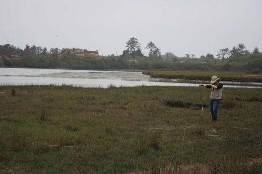
Time for Some Cool Shade. Farmlands along our central coast are planted with crops that thrive in such unique microclimates. Persistent summer sea breezes and moist marine layers keep temperatures mild and relative humidities high compared to inland regions with harsher extremes, such as in the Central Valley. Low cloud cover and high humidity also cut evapotranspiration rates so that less irrigation is required. After the morning burnoff, these broken stratus have drifted in with the afternoon sea breeze. They cast some thin cool shade over recently planted crops in this August scene just south of Oceano.Precious Water in and from the Sky. This stream flows away from nearby inland farmlands, through the coastal dunes at Oso Flaco Preserve, and into the sea just behind us. Above it all, an August afternoon air mass has warmed to nearly evaporate stubborn stratus within a rather thick marine layer stuck beneath the typical central coast summer inversion. Such cool, moist summer air helps to dampen otherwise harsh, dehydrating conditions that challenge coastal dune plants to survive prolonged seasonal drought. It has been more than three months since there was substantial precipitation on these dunes and it will be another three months before showers will return to dampen the dunes and begin recharging central coast streams such as these.
Following the Cycles We can only speculate what weather patterns the next cool rainy season might bring, particularly in a state and world where climate change repeatedly introduces new uncertainties and more complicated variables. But we can always appreciate how every decorative cloud and changing weather pattern offers another delightful opportunity to discover the science behind the weather scenes. During the months ahead, we will continue to observe and interpret nature’s sky dome canvas in our stories; they are leading up to a new publication celebrating the diversity of California’s evolving diurnal and seasonal weather and climate cycles.
Maps for Perspective: For those of you who may not be as familiar with our Golden State, or need a clearer overview perspective, we have displayed many different types of California maps in this project. But here are two outside links with physical maps that allow you to make your own comparisons and transects between the eastern Sierra Nevada and Central Coast locations we have visited in this story: